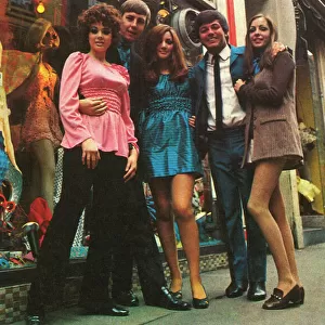
Jigsaw Puzzle : Carnaby Street 1966


![]()
Jigsaw Puzzles from Mary Evans Picture Library
Carnaby Street 1966
Map of Carnaby Street, fashionable centre of swinging sixties London, with a key showing the location of clothing boutiques and Cranks wholefood restaurants. Date: 1966
Mary Evans Picture Library makes available wonderful images created for people to enjoy over the centuries
Media ID 14243328
© Illustrated London News Ltd/Mary Evans
1966 Boutiques Carnaby Cool Cranks Swinging Fashionable
Jigsaw Puzzle (1000 Pieces)
Step back in time with our captivating Carnaby Street 1966 jigsaw puzzle from Media Storehouse! This intricately detailed puzzle, featuring an authentic map of the iconic London street from 1966, brings the swinging sixties to life. Discover the fashionable heart of London as you piece together the location of famous clothing boutiques and Cranks wholefood restaurants. Immerse yourself in history and create a stunning display piece that's sure to be a conversation starter.
1000 piece puzzles are custom made in Australia and hand-finished on 100% recycled 1.6mm thick laminated puzzle boards. There is a level of repetition in jigsaw shapes with each matching piece away from its pair. The completed puzzle measures 76x50cm and is delivered packaged in an attractive presentation box specially designed to fit most mail slots with a unique magnetic lid
Jigsaw Puzzles are an ideal gift for any occasion
Estimated Product Size is 50.2cm x 76cm (19.8" x 29.9")
These are individually made so all sizes are approximate
Artwork printed orientated as per the preview above, with landscape (horizontal) or portrait (vertical) orientation to match the source image.
EDITORS COMMENTS
Carnaby Street, London, 1966: A Map of the Fashionable Heart of Swinging Sixties London This vintage print captures the essence of Carnaby Street in 1966, a time when this iconic London thoroughfare became synonymous with the cool, fashionable, and avant-garde spirit of the 1960s. The map, with its intricate key, invites us to explore the vibrant and diverse world of Carnaby Street, a place where fashion and culture collided, giving birth to a new era of style and self-expression. Located in the heart of the West End, Carnaby Street was a bustling hub of creativity and innovation, attracting visitors from all corners of the globe. The map highlights the location of numerous clothing boutiques, each one offering a unique and eclectic selection of garments that defied the conventional norms of the time. From psychedelic prints and mod styles to tailored suits and hippie chic, Carnaby Street was the place to be for anyone who wanted to make a statement and stand out from the crowd. But Carnaby Street was more than just a fashion destination. It was also home to a number of Cranks wholefood restaurants, which were a welcome alternative to the greasy spoons and traditional British eateries that dominated the London food scene. The map shows the location of these eateries, which offered a healthier and more sustainable option for those who wanted to fuel their bodies as well as their minds and wardrobes. This map is a fascinating snapshot of a bygone era, a time when London was at the forefront of cultural and fashion trends. It invites us to step back in time and experience the excitement and energy of Carnaby Street in 1966, a place where anything was possible and the only limit was your imagination.
MADE IN AUSTRALIA
Safe Shipping with 30 Day Money Back Guarantee
FREE PERSONALISATION*
We are proud to offer a range of customisation features including Personalised Captions, Color Filters and Picture Zoom Tools
SECURE PAYMENTS
We happily accept a wide range of payment options so you can pay for the things you need in the way that is most convenient for you
* Options may vary by product and licensing agreement. Zoomed Pictures can be adjusted in the Cart.