Jigsaw Puzzle > Africa > Related Images
Jigsaw Puzzle : Map of British Empire showing international cable


![]()
Jigsaw Puzzles from Mary Evans Picture Library
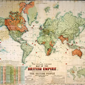
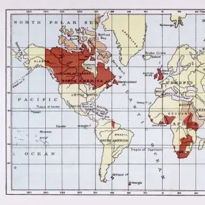
Map of British Empire showing international cable
Map of the British Empire (coloured red), showing the All-British international cable going round the world, enabling telegraphic communication. Date: circa 1902
Mary Evans Picture Library makes available wonderful images created for people to enjoy over the centuries
Media ID 14164147
© Mary Evans / Pharcide
Cable Commonwealth Communication Guiana Honduras Jack Patriotic Patriotism Technology Telegraph Telegraphic Zealand 1902
Jigsaw Puzzle (1000 Pieces)
Discover the rich history of global communication with our captivating "Map of British Empire" jigsaw puzzle from Media Storehouse. This intricately designed puzzle features an antique map of the British Empire, brilliantly colored in red, showcasing the vast expanse of the empire at the turn of the 20th century. The puzzle's central focus is the All-British international cable, depicted in intricate detail, encircling the globe. This historical puzzle is a perfect representation of the telegraphic revolution that connected the world like never before. Assemble this intriguing puzzle to not only challenge your problem-solving skills but also to immerse yourself in a piece of history that shaped the modern world. A delightful and educational activity for all ages. This beautifully designed jigsaw puzzle is brought to you by Media Storehouse, your trusted partner for high-quality, captivating puzzles.
1000 piece puzzles are custom made in Australia and hand-finished on 100% recycled 1.6mm thick laminated puzzle boards. There is a level of repetition in jigsaw shapes with each matching piece away from its pair. The completed puzzle measures 76x50cm and is delivered packaged in an attractive presentation box specially designed to fit most mail slots with a unique magnetic lid
Jigsaw Puzzles are an ideal gift for any occasion
Estimated Product Size is 76cm x 50.2cm (29.9" x 19.8")
These are individually made so all sizes are approximate
Artwork printed orientated as per the preview above, with landscape (horizontal) or portrait (vertical) orientation to match the source image.
FEATURES IN THESE COLLECTIONS
> Africa
> Related Images
> Asia
> India
> Related Images
> Europe
> United Kingdom
> Maps
> Maps and Charts
> British Empire Maps
> Maps and Charts
> Early Maps
> Maps and Charts
> India
> Maps and Charts
> Related Images
EDITORS COMMENTS
This map print, dated circa 1902, presents a vivid representation of the British Empire at the height of its global influence. The map is adorned with the red hue, symbolizing the territorial reach of the British monarchy, which extended across every corner of the world. At the heart of this imperial tapestry lies an intricate network of international telegraph cables, depicted in thick, unbroken lines. These cables, a marvel of late-Victorian technology, encircled the globe, connecting the far-flung corners of the Empire and enabling instantaneous telegraphic communication. The map's title, "Map of the British Empire," is accompanied by the image of the Union Jack flag, a potent symbol of British patriotism and unity. The flags of various dominions, including Canada, Australia, India, New Zealand, and even Guiana and Honduras, are also displayed, reflecting the diverse and expansive nature of the Empire. This map serves as a testament to the remarkable achievements of the British Empire during this period, as well as the transformative impact of telegraphic communication technology on global connections. The ability to send messages across vast distances in a matter of minutes revolutionized the way information was shared, facilitated diplomacy, and fostered a sense of unity among the disparate parts of the Empire. As you gaze upon this evocative map, one cannot help but be struck by the sense of awe and wonder that must have accompanied the realization of such a vast and interconnected world. This historical artifact is a poignant reminder of the past, offering valuable insights into the rich tapestry of British history and the enduring legacy of the Empire.
MADE IN AUSTRALIA
Safe Shipping with 30 Day Money Back Guarantee
FREE PERSONALISATION*
We are proud to offer a range of customisation features including Personalised Captions, Color Filters and Picture Zoom Tools
SECURE PAYMENTS
We happily accept a wide range of payment options so you can pay for the things you need in the way that is most convenient for you
* Options may vary by product and licensing agreement. Zoomed Pictures can be adjusted in the Cart.