Jigsaw Puzzle : Map of the Niagara Falls


![]()
Jigsaw Puzzles from Mary Evans Picture Library
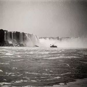
Map of the Niagara Falls
Map of the Niagara Falls. Date: circa 1890
Mary Evans Picture Library makes available wonderful images created for people to enjoy over the centuries
Media ID 14410966
© The Boswell Collection, Bexley Heritage Trust / Mary Evans
Chart Falls Ferry Goat Horseshoe Luna Niagara Plan Railroad
Jigsaw Puzzle (500 Pieces)
Discover the wonders of Niagara Falls with our captivating jigsaw puzzle from Media Storehouse. This intricately detailed puzzle features an antique map of the Niagara Falls, dated circa 1890, sourced from Mary Evans Prints Online. Immerse yourself in the history and beauty of this natural wonder as you piece together the intricacies of the map. A perfect activity for puzzle enthusiasts and history buffs alike, this challenging yet rewarding puzzle is sure to provide hours of enjoyment.
500 piece puzzles are custom made in Australia and hand-finished on 100% recycled 1.6mm thick laminated puzzle boards. There is a level of repetition in jigsaw shapes with each matching piece away from its pair. The completed puzzle measures 40x51cm and is delivered packaged in an attractive presentation box specially designed to fit most mail slots with a unique magnetic lid
Jigsaw Puzzles are an ideal gift for any occasion
Estimated Product Size is 50.7cm x 40.3cm (20" x 15.9")
These are individually made so all sizes are approximate
Artwork printed orientated as per the preview above, with landscape (horizontal) or portrait (vertical) orientation to match the source image.
EDITORS COMMENTS
Step back in time with this map print of Niagara Falls from the late 19th century. Dated circa 1890, this intricately detailed lantern slide offers a bird's eye view of the awe-inspiring natural wonder straddling the border between the United States and Canada. The map highlights the various landmarks and attractions surrounding the falls, including the Horseshoe Falls, Luna Island, Goat Island, and the Central Ferry. The railroad line running along the American side of the Niagara River is also clearly visible. This map provides a glimpse into the past, offering insight into the transportation methods and infrastructure of the time. The presence of the ferry and railroad suggest that tourism was already a significant industry in the late 1800s, drawing visitors from near and far to witness the breathtaking beauty of Niagara Falls. The intricate details of the map, from the winding river to the labeled landmarks, offer a fascinating look into the past. The map's age and historical significance make it a valuable addition to any collection, transporting us back to a time when the wonder of Niagara Falls drew people together from all corners of the world.
MADE IN AUSTRALIA
Safe Shipping with 30 Day Money Back Guarantee
FREE PERSONALISATION*
We are proud to offer a range of customisation features including Personalised Captions, Color Filters and Picture Zoom Tools
FREE COLORIZATION SERVICE
You can choose advanced AI Colorization for this picture at no extra charge!
SECURE PAYMENTS
We happily accept a wide range of payment options so you can pay for the things you need in the way that is most convenient for you
* Options may vary by product and licensing agreement. Zoomed Pictures can be adjusted in the Cart.