Jigsaw Puzzle > Asia > India > Maps
Jigsaw Puzzle : Map / Asia / India C1850


![]()
Jigsaw Puzzles from Mary Evans Picture Library
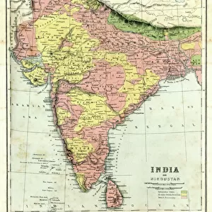
Map / Asia / India C1850
India under British rule, about the time of the Mutiny
Mary Evans Picture Library makes available wonderful images created for people to enjoy over the centuries
Media ID 576626
© Mary Evans Picture Library 2015 - https://copyrighthub.org/s0/hub1/creation/maryevans/MaryEvansPictureID/10015681
Jigsaw Puzzle (500 Pieces)
Discover the rich history of India under British rule with our captivating jigsaw puzzle from the Media Storehouse collection. Featuring the iconic image "Map / Asia / India C1850" by Mary Evans Picture Library from Mary Evans Prints Online, this puzzle transports you back in time to an era of intrigue and exploration. Immerse yourself in the intricate details of this stunning map, meticulously recreated in puzzle form for hours of engaging and educational fun. Perfect for history enthusiasts, puzzle lovers, or anyone seeking a challenging and rewarding pastime, this puzzle is a must-have addition to your collection. Unleash your inner detective and piece together the story of India's past, one puzzle piece at a time.
500 piece puzzles are custom made in Australia and hand-finished on 100% recycled 1.6mm thick laminated puzzle boards. There is a level of repetition in jigsaw shapes with each matching piece away from its pair. The completed puzzle measures 40x51cm and is delivered packaged in an attractive presentation box specially designed to fit most mail slots with a unique magnetic lid
Jigsaw Puzzles are an ideal gift for any occasion
Estimated Product Size is 40.3cm x 50.7cm (15.9" x 20")
These are individually made so all sizes are approximate
Artwork printed orientated as per the preview above, with landscape (horizontal) or portrait (vertical) orientation to match the source image.
FEATURES IN THESE COLLECTIONS
> Asia
> India
> Related Images
> Asia
> Related Images
> Maps and Charts
> Early Maps
> Maps and Charts
> India
> Maps and Charts
> Related Images
> Mary Evans Prints Online
> Maps
EDITORS COMMENTS
This print from Mary Evans Picture Library showcases a detailed map of Asia, specifically focusing on India around the year 1850. During this time, India was under British rule, and tensions were rising leading up to the Indian Mutiny.
The map itself is a fascinating glimpse into the past, showing the intricate borders and regions of India as it existed during this pivotal period in history. The level of detail in the map allows viewers to truly immerse themselves in the geography and political landscape of India at that time.
As we study this map, we can't help but reflect on the complex dynamics at play during this era - from colonialism to resistance movements. The presence of British rule looms large over the country, with implications that would shape India's future for generations to come.
Overall, this print serves as a powerful reminder of India's rich history and its struggles for independence. It captures a moment frozen in time when change was on the horizon and revolution was brewing. A true historical treasure that offers valuable insights into one of Asia's most influential nations during a critical juncture in its development.
MADE IN AUSTRALIA
Safe Shipping with 30 Day Money Back Guarantee
FREE PERSONALISATION*
We are proud to offer a range of customisation features including Personalised Captions, Color Filters and Picture Zoom Tools
FREE COLORIZATION SERVICE
You can choose advanced AI Colorization for this picture at no extra charge!
SECURE PAYMENTS
We happily accept a wide range of payment options so you can pay for the things you need in the way that is most convenient for you
* Options may vary by product and licensing agreement. Zoomed Pictures can be adjusted in the Cart.