Jigsaw Puzzle > Maps and Charts > World
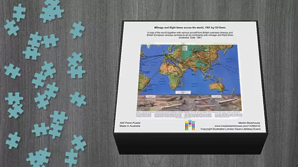
Jigsaw Puzzle : Mileage and flight times across the world, 1961 by GH Davis


![]()
Jigsaw Puzzles from Mary Evans Picture Library
Mileage and flight times across the world, 1961 by GH Davis
A map of the world together with various aircraft from British overseas airways and British European airways services to all six continents with mileage and flight times illustrated. Date: 1961
Mary Evans Picture Library makes available wonderful images created for people to enjoy over the centuries
Media ID 14266432
© Illustrated London News Ltd/Mary Evans
Airways Davis Diagram Distance Horace Maps Mileage Oct17 Times
Jigsaw Puzzle (500 Pieces)
Discover the thrill of the past with our captivating Mileage and Flight Times across the World jigsaw puzzle from Media Storehouse. This intriguing puzzle, featuring the iconic 1961 map by GH Davis from Mary Evans Prints Online, invites you on a journey back in time. Explore the world as it was in 1961, with British Overseas Airways and British European Airways services connecting all six continents. Each piece of this challenging puzzle represents a piece of aviation history, as you put together the mileage and flight times for each route. Ideal for puzzle enthusiasts, history buffs, and aviation fans, this collectible puzzle offers hours of entertainment and a beautiful display piece once completed.
500 piece puzzles are custom made in Australia and hand-finished on 100% recycled 1.6mm thick laminated puzzle boards. There is a level of repetition in jigsaw shapes with each matching piece away from its pair. The completed puzzle measures 40x51cm and is delivered packaged in an attractive presentation box specially designed to fit most mail slots with a unique magnetic lid
Jigsaw Puzzles are an ideal gift for any occasion
Estimated Product Size is 50.7cm x 40.3cm (20" x 15.9")
These are individually made so all sizes are approximate
Artwork printed orientated as per the preview above, with landscape (horizontal) or portrait (vertical) orientation to match the source image.
FEATURES IN THESE COLLECTIONS
> Europe
> Related Images
> Maps and Charts
> Related Images
> Maps and Charts
> World
EDITORS COMMENTS
This vintage print, titled "Mileage and flight times across the world, 1961," is a mesmerizing diagram created by the skilled hand of British cartographer and illustrator, George Horace Davis. The intricately detailed map showcases the vast expanse of the world, meticulously marked with the flight routes and corresponding mileage and flight times of various aircraft from British Overseas Airways and British European Airways. The image transports us back in time to an era of optimistic exploration and adventure in the skies. Davis' meticulous attention to detail is evident in the illustrations of the aeroplanes gracing the map, each labeled with its respective flight number and distance from its origin. The aircraft, ranging from propeller-driven models to early jetliners, are depicted in action, soaring above the continents they connect. The map itself is a work of art, with each continent delicately outlined in bold, contrasting colors. The oceans are a deep blue, and the various countries are represented by their flags. The flight paths crisscross the map, connecting the dots between far-flung destinations, creating a web of global connectivity. This print is a testament to the ingenuity and ambition of the aviation industry in the early 1960s, a time when the world seemed smaller and more accessible than ever before. Davis' "Mileage and flight times across the world, 1961" is a fascinating glimpse into the past, offering a unique perspective on the history of air travel and the world as it was once known.
MADE IN AUSTRALIA
Safe Shipping with 30 Day Money Back Guarantee
FREE PERSONALISATION*
We are proud to offer a range of customisation features including Personalised Captions, Color Filters and Picture Zoom Tools
SECURE PAYMENTS
We happily accept a wide range of payment options so you can pay for the things you need in the way that is most convenient for you
* Options may vary by product and licensing agreement. Zoomed Pictures can be adjusted in the Cart.