Jigsaw Puzzle > Africa > Morocco > Maps
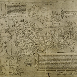
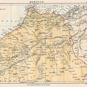
Jigsaw Puzzle : MAP / AFRICA / MOROCCO 1719


![]()
Jigsaw Puzzles from Mary Evans Picture Library
MAP / AFRICA / MOROCCO 1719
LEmpire du Cherif de Fez, Maroc, Sus &c. the Moroccan empire in the early 18th century, with the Atlas Mountains and the Sahara Date: 1719
Mary Evans Picture Library makes available wonderful images created for people to enjoy over the centuries
Media ID 20143953
© Bubblepunk
1719 Atlas Cherif Maps Maroc Moroccan Morocco Sahara
Jigsaw Puzzle (1000 Pieces)
Discover the rich history and beauty of Morocco with our captivating jigsaw puzzle from the Media Storehouse collection. This intricately detailed puzzle, featuring the map "MAP / AFRICA / MOROCCO 1719" from Mary Evans Prints Online, invites you on an adventure through the Moroccan empire in the early 18th century. Explore the Atlas Mountains, the Sahara, and the lands of Sus and Fez as depicted in this historical map. With vibrant colors and intricate details, this puzzle is perfect for history enthusiasts, puzzle collectors, or anyone in search of a challenging and rewarding puzzle experience.
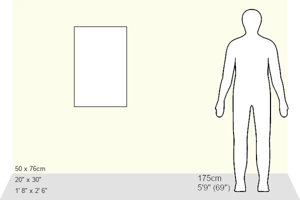
1000 piece puzzles are custom made in Australia and hand-finished on 100% recycled 1.6mm thick laminated puzzle boards. There is a level of repetition in jigsaw shapes with each matching piece away from its pair. The completed puzzle measures 76x50cm and is delivered packaged in an attractive presentation box specially designed to fit most mail slots with a unique magnetic lid
Jigsaw Puzzles are an ideal gift for any occasion
Estimated Product Size is 50.2cm x 76cm (19.8" x 29.9")
These are individually made so all sizes are approximate
Artwork printed orientated as per the preview above, with landscape (horizontal) or portrait (vertical) orientation to match the source image.
FEATURES IN THESE COLLECTIONS
> Africa
> Morocco
> Related Images
> Africa
> Related Images
> Maps and Charts
> Early Maps
> Maps and Charts
> Related Images
> Mary Evans Prints Online
> New Images July 2020
EDITORS COMMENTS
This exquisite map print, titled "Empire du Cherif de Fez, Maroc, Sus &c." and dated 1719, offers a captivating glimpse into the Moroccan empire during the early 18th century. The map, from the Mary Evans Prints Online collection, provides a detailed and intricate depiction of Morocco's geography, with a focus on the regions of Fez, Maroc, and Sus. The map's central feature is the representation of the Atlas Mountains, a mountain range that stretches from northwest Africa through Algeria and Tunisia. The Atlas Mountains are depicted in stunning detail, with their peaks and valleys accurately rendered. The Sahara desert, to the south, is also shown, its vast expanse of sand dunes and oases contrasting sharply with the mountainous terrain to the north. The Moroccan empire at this time was ruled by the Alaouite dynasty, with the city of Fez serving as the spiritual and cultural center of the kingdom. The map reflects the empire's political divisions, with various provinces and territories labeled in intricate detail. The map also includes several notable cities, such as Marrakech, Rabat, and Tangier, as well as important landmarks, such as the Strait of Gibraltar and the Rif Mountains. The map's intricate detail and accurate representation of the geography of Morocco during this period make it an invaluable resource for historians, geographers, and anyone interested in the history of North Africa. The map's beautiful and ornate design, with its use of intricate cartouches and detailed border, adds to its aesthetic appeal and makes it a true work of art. Overall, this map print offers a fascinating glimpse into the Moroccan empire during the early 18th century, a time of political and cultural significance in North African history.
MADE IN AUSTRALIA
Safe Shipping with 30 Day Money Back Guarantee
FREE PERSONALISATION*
We are proud to offer a range of customisation features including Personalised Captions, Color Filters and Picture Zoom Tools
SECURE PAYMENTS
We happily accept a wide range of payment options so you can pay for the things you need in the way that is most convenient for you
* Options may vary by product and licensing agreement. Zoomed Pictures can be adjusted in the Cart.