Jigsaw Puzzle > North America > Canada > Lakes > Lake Erie
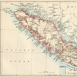
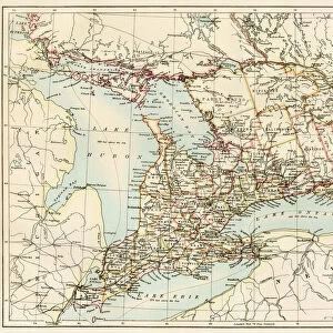
Jigsaw Puzzle : Ontario, 1870s


![]()
Jigsaw Puzzles from North Wind
Ontario, 1870s
Map of Ontario, Canada, 1870s.
Printed color lithograph
North Wind Picture Archives brings history to life with stock images and hand-colored illustrations
Media ID 5879739
© North Wind Picture Archives
1870s Canada Canadian Great Lakes Lake Erie Lake Ontario Ontario Georgian Bay Lake Huron
Jigsaw Puzzle (1000 Pieces)
Step back in time with our exquisite Ontario, 1870s jigsaw puzzle from Media Storehouse and North Wind Picture Archives. This captivating puzzle features a detailed, printed color lithograph of Ontario, Canada, as it looked over a century ago. Immerse yourself in the history of this beautiful region, as you piece together the intricately designed borders, rivers, and towns. A perfect gift for history enthusiasts, puzzle lovers, or anyone seeking a challenging and educational pastime. Discover the stories hidden within each puzzle piece and bring the past to life with our Ontario, 1870s puzzle.
1000 piece puzzles are custom made in Australia and hand-finished on 100% recycled 1.6mm thick laminated puzzle boards. There is a level of repetition in jigsaw shapes with each matching piece away from its pair. The completed puzzle measures 76x50cm and is delivered packaged in an attractive presentation box specially designed to fit most mail slots with a unique magnetic lid
Jigsaw Puzzles are an ideal gift for any occasion
Estimated Product Size is 76cm x 50.2cm (29.9" x 19.8")
These are individually made so all sizes are approximate
Artwork printed orientated as per the preview above, with landscape (horizontal) or portrait (vertical) orientation to match the source image.
FEATURES IN THESE COLLECTIONS
> Asia
> Georgia
> Related Images
> Maps and Charts
> Related Images
> North America
> Canada
> Lakes
> Lake Erie
> North America
> Canada
> Lakes
> Lake Huron
> North America
> Canada
> Lakes
> Lake Ontario
> North America
> Canada
> Lakes
> Related Images
> North America
> Canada
> Maps
> North Wind Picture Archives
> Canadian history
> North Wind Picture Archives
> Maps
EDITORS COMMENTS
This vintage print takes us back to the 1870s, offering a captivating glimpse into the history of Ontario, Canada. The beautifully detailed map showcases the province's vast landscapes and waterways in stunning printed color lithograph. As we explore this piece of art, we are transported to a time when traditional heritage and historic illustrations were valued. The 19th-century illustration highlights Ontario's significant role in Canadian history. It depicts the region's expansive territory, stretching from Lake Erie to Georgian Bay and encompassing iconic landmarks such as Lake Ontario and Lake Huron. These Great Lakes served as vital transportation routes during that era, connecting communities across North America. As we delve deeper into this artwork, it becomes evident that it is more than just a map; it is an artistic representation of Ontario's natural beauty. The attention to detail captures the essence of the province's diverse geography - from rolling hills to dense forests - inviting viewers to appreciate its breathtaking scenery. This print not only serves as a historical artifact but also as a reminder of our connection with nature and our roots. It allows us to reflect on how much has changed since those early days while appreciating the timeless allure of Ontario’s landscape
MADE IN AUSTRALIA
Safe Shipping with 30 Day Money Back Guarantee
FREE PERSONALISATION*
We are proud to offer a range of customisation features including Personalised Captions, Color Filters and Picture Zoom Tools
SECURE PAYMENTS
We happily accept a wide range of payment options so you can pay for the things you need in the way that is most convenient for you
* Options may vary by product and licensing agreement. Zoomed Pictures can be adjusted in the Cart.