Home > Asia > Palestine > Maps
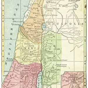
etc Bartholomew map Palestine 1900

![]()
Wall Art and Photo Gifts from Liszt Collection
etc Bartholomew map Palestine 1900
etc. Bartholomews map of Palestine 1900
Liszt Collection of nineteenth-century engravings and images to browse and enjoy
Media ID 18536716
© Liszt Collection
FEATURES IN THESE COLLECTIONS
> Asia
> Palestine
> Related Images
> Maps and Charts
> Related Images
EDITORS COMMENTS
This print showcases the remarkable "Bartholomew Map of Palestine 1900" from the prestigious Liszt Collection. Steeped in historical significance, this meticulously detailed map offers a fascinating glimpse into the intricate geography and cultural tapestry of Palestine at the turn of the century. With its rich hues and exquisite craftsmanship, this print transports viewers to a bygone era when cartography was both an art form and a vital tool for exploration. The Bartholomew Map effortlessly captures every nuance of the region's topography, highlighting mountains, rivers, cities, and villages with unparalleled precision. As we delve into this mesmerizing piece, we are transported back to a time when borders were fluid and cultures intermingled harmoniously. This map serves as a testament to human curiosity and our innate desire to understand our surroundings. The Liszt Collection has masterfully preserved this rare gem from history for all to admire. It is not only an object of beauty but also an invaluable resource for historians, researchers, or anyone seeking insight into Palestine's past. Whether you are captivated by ancient civilizations or simply appreciate fine artistry, this print will undoubtedly leave you awe-inspired. Let it adorn your walls as a reminder that knowledge knows no bounds and that even in today's fast-paced world, there is always room for reflection on our shared heritage.
MADE IN AUSTRALIA
Safe Shipping with 30 Day Money Back Guarantee
FREE PERSONALISATION*
We are proud to offer a range of customisation features including Personalised Captions, Color Filters and Picture Zoom Tools
SECURE PAYMENTS
We happily accept a wide range of payment options so you can pay for the things you need in the way that is most convenient for you
* Options may vary by product and licensing agreement. Zoomed Pictures can be adjusted in the Cart.