Home > Maps and Charts > Related Images
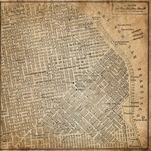
Map of Nantes

![]()
Wall Art and Photo Gifts from Liszt Collection
Map of Nantes
MAP OF NANTES
Liszt Collection of nineteenth-century engravings and images to browse and enjoy
Media ID 12980513
© Quint Lox Limited
FEATURES IN THESE COLLECTIONS
> Liszt Collection
> Engravings
> Maps and Charts
> Related Images
EDITORS COMMENTS
This print titled "Map of Nantes" takes us on a nostalgic journey back to the nineteenth century. The intricate details and illustrative technique used in this engraved image transport us to a bygone era, where maps were meticulously crafted works of art. With its retro-styled charm and vintage appeal, this piece from the Liszt Collection is sure to captivate history enthusiasts and art lovers alike. The Map of Nantes showcases the city's layout during a time when it was undergoing significant transformations. Every street, building, and landmark is intricately etched onto the map with remarkable precision, providing an invaluable glimpse into the past. As we explore this historical chart, we can almost imagine ourselves wandering through the cobbled streets of old Nantes. The Victorian influence is evident in every stroke of this engravement; it exudes an air of elegance that transports us back to a time when attention to detail was paramount. This artistic representation not only serves as a geographical guide but also tells stories about the culture and heritage that shaped Nantes. Whether displayed in homes or offices, this print adds a touch of sophistication while celebrating both arts and history. It invites viewers to immerse themselves in another era—where horse-drawn carriages traversed bustling streets—and offers endless opportunities for exploration and discovery within its beautifully rendered lines.
MADE IN AUSTRALIA
Safe Shipping with 30 Day Money Back Guarantee
FREE PERSONALISATION*
We are proud to offer a range of customisation features including Personalised Captions, Color Filters and Picture Zoom Tools
SECURE PAYMENTS
We happily accept a wide range of payment options so you can pay for the things you need in the way that is most convenient for you
* Options may vary by product and licensing agreement. Zoomed Pictures can be adjusted in the Cart.