Home > Europe > United Kingdom > England > London > Towns > Mill Hill
Rugby CV23 8 Map

![]()
Wall Art and Photo Gifts from Map Marketing
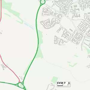
Rugby CV23 8 Map
Postcode Sector Map of Rugby CV23 8
Media ID 19968214
Almond Close Ashby Road Ashleigh Close Back Lane Brooks Close Castle Lane Chapel Street Church Road Church Walk College Road Cut Throat Lane Daventry Road Emery Close Fishers Close Hall Close Hill Hill Road London Road Lower Street Magdalen Road Main Road Main Street Manor Farm Close Manor Road Marton Road Middle Street Moor Lane North Street Rectory Close Rectory Lane Rugby Rugby Road School Close Spring Close The Banks The Green The Lane The Lawns The Old Orchard The Ridgeway Vicarage Road Ware Road Watling Street Broadwell Sawbridge Willoughby
FEATURES IN THESE COLLECTIONS
> Map Marketing
> Postcode Sector Maps
> CV - Coventry
> Animals
> Mammals
> Bovidae
> Ox
> Arts
> Portraits
> Pop art gallery
> Street art portraits
> Europe
> United Kingdom
> England
> Devon
> Church Green
> Europe
> United Kingdom
> England
> Devon
> Cowley
> Europe
> United Kingdom
> England
> Devon
> Related Images
> Europe
> United Kingdom
> England
> Devon
> Vicarage
> Europe
> United Kingdom
> England
> London
> Related Images
> Europe
> United Kingdom
> England
> London
> Sport
> Rugby
> Europe
> United Kingdom
> England
> London
> Towns
> Mill Hill
> Maps and Charts
> Related Images
MADE IN AUSTRALIA
Safe Shipping with 30 Day Money Back Guarantee
FREE PERSONALISATION*
We are proud to offer a range of customisation features including Personalised Captions, Color Filters and Picture Zoom Tools
SECURE PAYMENTS
We happily accept a wide range of payment options so you can pay for the things you need in the way that is most convenient for you
* Options may vary by product and licensing agreement. Zoomed Pictures can be adjusted in the Cart.