Home > Europe > United Kingdom > England > London > Boroughs > Ealing
Harrow HA0 4 Map

![]()
Wall Art and Photo Gifts from Map Marketing
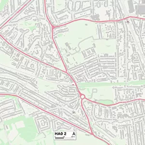
Harrow HA0 4 Map
Postcode Sector Map of Harrow HA0 4
Media ID 19971407
Belmont Avenue Braemar Avenue Bridgeway Chaplin Road Christchurch Avenue Clayton Avenue Clifton Way Dorothy Avenue Douglas Avenue Eagle Road Egerton Road Fairview Avenue Farm Avenue Harley Close Harrow Haynes Road Holland Road Lincoln Road Lomond Close Montrose Crescent Mount Pleasant Newton Road Norton Road Orchard Close Park Road Rowley Close St James Gardens Stanley Avenue Stanley Close Stapleford Road Talbot Road The Close Union Road Valley Gardens Vincent Road Westbury Avenue Westbury Road Woodstock Road
FEATURES IN THESE COLLECTIONS
> Map Marketing
> Postcode Sector Maps
> HA - Harrow
> Arts
> Artists
> H
> James Holland
> Arts
> Artists
> Q
> Queen Victoria Queen Victoria
> Arts
> Artists
> S
> Dorothy Stanley
> Europe
> United Kingdom
> England
> London
> Boroughs
> Ealing
> Europe
> United Kingdom
> England
> London
> Boroughs
> Harrow
> Europe
> United Kingdom
> England
> London
> Sights
> Holland Park
> Europe
> United Kingdom
> England
> London
> Sights
> St James Park
> Europe
> United Kingdom
> England
> London
> Sights
> Victoria Park
> Europe
> United Kingdom
> Scotland
> Angus
> Montrose
> Maps and Charts
> Related Images
MADE IN AUSTRALIA
Safe Shipping with 30 Day Money Back Guarantee
FREE PERSONALISATION*
We are proud to offer a range of customisation features including Personalised Captions, Color Filters and Picture Zoom Tools
SECURE PAYMENTS
We happily accept a wide range of payment options so you can pay for the things you need in the way that is most convenient for you
* Options may vary by product and licensing agreement. Zoomed Pictures can be adjusted in the Cart.