Home > Animals > Birds > Passerines > Finches > Brambling
Ashfield NG17 1 Map

![]()
Wall Art and Photo Gifts from Map Marketing
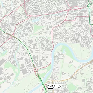
Ashfield NG17 1 Map
Postcode Sector Map of Ashfield NG17 1
Media ID 19974404
Alfreton Road Ashfield Blackthorn Way Brook Street Chestnut Gardens Church Hill Church Lane Church Mews Church Street Clumber Street Collins Avenue Dovedale Avenue Field View Forest Street Fox Street Frederick Street Garth Avenue Gill Street Grange Farm Close Grosvenor Avenue Hedgerow Close High Street Highland Drive Hill Top View King Street Kirkby Road Lammas Close Lammas Road Langton Road Lynton Drive Manor Street Market Street Mayfield Place Mill Croft Mill Street Morven Avenue New Street Ng17 Nursery Avenue Orchard Way Parliament Street Percy Street Primrose Way Prospect Place Rosedale Gardens Spring Road Station Street The Avenue The Shires Victoria Street Walton Drive West End Windrush Close Woodlands Way Fulwood
FEATURES IN THESE COLLECTIONS
> Map Marketing
> Postcode Sector Maps
> NG - Nottingham
> Animals
> Birds
> Passerines
> Finches
> Brambling
> Animals
> Birds
> Passerines
> Larks
> Related Images
> Arts
> Artists
> C
> Frederick Church
> Arts
> Landscape paintings
> Forest and woodland scenes
> Forest artwork
> Arts
> Portraits
> Pop art gallery
> Street art portraits
> Maps and Charts
> Related Images
MADE IN AUSTRALIA
Safe Shipping with 30 Day Money Back Guarantee
FREE PERSONALISATION*
We are proud to offer a range of customisation features including Personalised Captions, Color Filters and Picture Zoom Tools
SECURE PAYMENTS
We happily accept a wide range of payment options so you can pay for the things you need in the way that is most convenient for you
* Options may vary by product and licensing agreement. Zoomed Pictures can be adjusted in the Cart.