Home > Animals > Birds > Passerines > Crows And Jays > Related Images
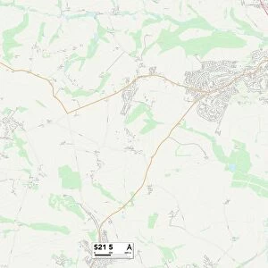
North East Derbyshire S45 8 Map

![]()
Wall Art and Photo Gifts from Map Marketing
North East Derbyshire S45 8 Map
Postcode Sector Map of North East Derbyshire S45 8
Media ID 19978822
Acacia Drive Acres Road Back Lane Bridge Street Broom Avenue Brunswick Street Church Street Dark Lane Deep Lane Elm Road Forest Drive Granby Close Grange Road Green Lane Hazel Avenue Lansbury Avenue Lonsdale Road Manor Close Manor Farm Morton Road Mulberry Walk New Street North East Derbyshire Old Hall Close Parkhouse Road Pear Tree Road Poplar Grove Prospect Road Queen Street Queensway Rupert Street Slacks Lane South Street Station Road The Acres The Green The Paddocks Valley Close Warren Close Willow Close
FEATURES IN THESE COLLECTIONS
> Map Marketing
> Postcode Sector Maps
> S - Sheffield
> Animals
> Birds
> Passerines
> Crows And Jays
> Related Images
> Arts
> Landscape paintings
> Forest and woodland scenes
> Forest artwork
> Arts
> Portraits
> Pop art gallery
> Street art portraits
> Europe
> United Kingdom
> England
> Derbyshire
> Morton
> Europe
> United Kingdom
> England
> Derbyshire
> Peak Dale
> Europe
> United Kingdom
> England
> Derbyshire
> Peak Forest
> Europe
> United Kingdom
> England
> Derbyshire
> Pilsley
> Europe
> United Kingdom
> England
> Derbyshire
> Related Images
> Maps and Charts
> Related Images
MADE IN AUSTRALIA
Safe Shipping with 30 Day Money Back Guarantee
FREE PERSONALISATION*
We are proud to offer a range of customisation features including Personalised Captions, Color Filters and Picture Zoom Tools
SECURE PAYMENTS
We happily accept a wide range of payment options so you can pay for the things you need in the way that is most convenient for you
* Options may vary by product and licensing agreement. Zoomed Pictures can be adjusted in the Cart.