Home > Europe > United Kingdom > Wales > Flintshire > Hawarden
Trafford WA14 1 Map

![]()
Wall Art and Photo Gifts from Map Marketing
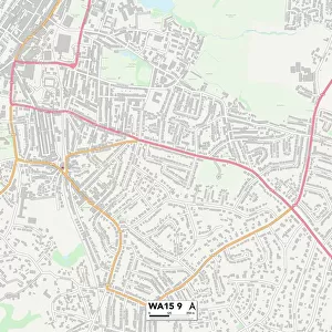
Trafford WA14 1 Map
Postcode Sector Map of Trafford WA14 1
Media ID 19979846
Albert Road Ashton Avenue Barrington Close Barrington Road Brentwood Avenue Brewery Street Bridgewater Road Brook Close Brunswick Road Burlington Road Canal Road Central Way Cross Street Derby Street Ellesmere Road Emery Close Garden Lane Gladstone Road Greenwood Street Harcourt Road Hart Street Hawarden Road Hazel Road High Street Market Street Mill Street Navigation Road Newton Road Northway Occupation Road Poplar Avenue Regent Road Skelton Road Southway Springfield Road Stamford Street The Causeway The Woods Trafford Victoria Street Wharf Road Wood Street Woodlands Road Altrincham
FEATURES IN THESE COLLECTIONS
> Map Marketing
> Postcode Sector Maps
> WA - Warrington
> Arts
> Portraits
> Pop art gallery
> Street art portraits
> Europe
> United Kingdom
> Wales
> Flintshire
> Hawarden
> Maps and Charts
> Related Images
MADE IN AUSTRALIA
Safe Shipping with 30 Day Money Back Guarantee
FREE PERSONALISATION*
We are proud to offer a range of customisation features including Personalised Captions, Color Filters and Picture Zoom Tools
SECURE PAYMENTS
We happily accept a wide range of payment options so you can pay for the things you need in the way that is most convenient for you
* Options may vary by product and licensing agreement. Zoomed Pictures can be adjusted in the Cart.