Home > Arts > Artists > T > John Tallis
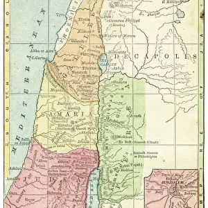
Modern Palestine 1851

![]()
Wall Art and Photo Gifts from MapSeeker
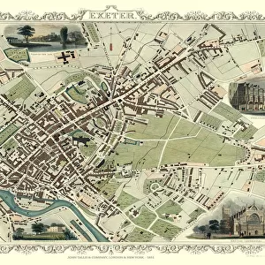
Modern Palestine 1851
A fine facimile artworked from an antique original map of Modern Palestine, issued as part of the 1851 edition of John Tallis and Companys " The Illustrated Atlas and Modern History of the World"
Welcome to the Mapseeker Image library and enter an historic gateway to one of the largest on-line collections of Historic Maps, Nostalgic Views, Vista's and Panorama's from a World gone by.
Media ID 20347340
© Mapseeker Publishing Ltd
John Tallis John Tallis Map Tallis Map
FEATURES IN THESE COLLECTIONS
> MapSeeker
> Maps of Asia and Middle East
> Maps of the Middle East and East Indies
> Arts
> Artists
> T
> John Tallis
> Asia
> Palestine
> Related Images
> Maps and Charts
> Related Images
> Maps and Charts
> World
EDITORS COMMENTS
This print showcases a remarkable piece of cartographic history - the Modern Palestine map from 1851, originally published in John Tallis and Company's "The Illustrated Atlas and Modern History of the World". Crafted with utmost precision and attention to detail, this fine facsimile artwork transports us back to a time when exploration and discovery were at their peak. John Tallis, renowned for his expertise in mapmaking, collaborated with talented artist John Rapkin to create this exquisite depiction of Modern Palestine. The map not only serves as an invaluable geographical reference but also offers a glimpse into the political landscape of that era. With its intricate borders, cities, rivers, mountains, and other topographical features meticulously illustrated on paper, it provides an immersive experience for any history enthusiast or geography aficionado. As we delve into this masterpiece's rich details, we are transported through time to witness how Palestine appeared over 150 years ago. It is fascinating to observe how boundaries have evolved since then while appreciating the artistry involved in bringing such historical documents to life. Whether displayed proudly on your wall or used as a tool for research or education purposes, this print allows you to connect with the past while admiring the skillful craftsmanship that went into creating it. A true testament to human curiosity and ingenuity!
MADE IN AUSTRALIA
Safe Shipping with 30 Day Money Back Guarantee
FREE PERSONALISATION*
We are proud to offer a range of customisation features including Personalised Captions, Color Filters and Picture Zoom Tools
SECURE PAYMENTS
We happily accept a wide range of payment options so you can pay for the things you need in the way that is most convenient for you
* Options may vary by product and licensing agreement. Zoomed Pictures can be adjusted in the Cart.