Home > Europe > United Kingdom > Scotland > Edinburgh > Edinburgh
Cover design, county map of Hampshire

![]()
Wall Art and Photo Gifts from Mary Evans Picture Library
Cover design, county map of Hampshire
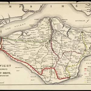
Cover design, county map of Hampshire for cyclists and tourists, in a series entitled Cruchleys County Maps of England, published by Gall & Inglis of London and Edinburgh. Date: early 20th century
Mary Evans Picture Library makes available wonderful images created for people to enjoy over the centuries
Media ID 14226948
© Mary Evans Picture Library / John Maclellan
Bright Cartography Cyclists Edinburgh Folding Gall Hampshire Hants Inglis Maps Publication Tourists
FEATURES IN THESE COLLECTIONS
> Europe
> United Kingdom
> England
> Hampshire
> Related Images
> Europe
> United Kingdom
> England
> London
> Related Images
> Europe
> United Kingdom
> England
> Maps
> Europe
> United Kingdom
> Scotland
> Edinburgh
> Edinburgh
> Europe
> United Kingdom
> Scotland
> Lothian
> Edinburgh
> Maps and Charts
> Early Maps
EDITORS COMMENTS
This cover design showcases the early 20th century County Map of Hampshire, published as part of the Cruchley County Maps of England series by Gall & Inglis of London and Edinburgh. The map is specifically tailored for the use of cyclists and tourists, making it an essential companion for those exploring the picturesque English county. The vibrant and detailed cover design features a bright blue background, contrasting beautifully with the intricate cartographic illustrations of Hampshire's counties, towns, and villages. The map itself is unfolded, revealing the meticulously drawn roads, waterways, and geographical features that crisscross the county. The Edwardian era, during which this map was published, saw a surge in popularity for cycling and tourism, making such maps an indispensable resource for travelers. The Cruchley County Maps of England series, produced by Gall & Inglis, gained a reputation for their high-quality cartography and attention to detail, making them a trusted guide for explorers during this period. The map's historical significance is further emphasized by its inclusion of place names, railway lines, and other key landmarks that provide a glimpse into Hampshire's rich history. The map's design, with its clear and concise labeling, makes it easy to navigate and use, ensuring that cyclists and tourists could make the most of their journeys through the beautiful English countryside. This cover design is a testament to the enduring appeal of vintage maps and the role they played in shaping our understanding of the world around us. It invites us to imagine the adventures of those who used it and to appreciate the beauty and intrigue of Hampshire, a county that continues to captivate visitors to this day.
MADE IN AUSTRALIA
Safe Shipping with 30 Day Money Back Guarantee
FREE PERSONALISATION*
We are proud to offer a range of customisation features including Personalised Captions, Color Filters and Picture Zoom Tools
SECURE PAYMENTS
We happily accept a wide range of payment options so you can pay for the things you need in the way that is most convenient for you
* Options may vary by product and licensing agreement. Zoomed Pictures can be adjusted in the Cart.