Home > Europe > Italy > Sicily > Messina
Lopo Homem (16th c. ); REINEL, Jorge (1502 - 1572)
; REINEL, Jorge (1502 - 1572)")
![]()
Wall Art and Photo Gifts from Mary Evans Picture Library
Lopo Homem (16th c. ); REINEL, Jorge (1502 - 1572)
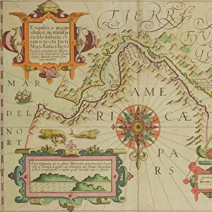
Lopo Homem (16th c.); REINEL, Jorge (1502 - 1572); REINEL, Pedro (ca. 1462 - 1542). Atlas Miller. 1519. Portolan chart, 1587. Map of Western Europe and North Africa. Printed in Messina. Facsimile. Renaissance art. Miniature Painting. FRANCE. Paris. National Library
Mary Evans Picture Library makes available wonderful images created for people to enjoy over the centuries
Media ID 8282453
© Mary Evans/J. Bedmar/Iberfoto
Atlas Chart Facsimile Jorge Messina Miller Pedro Portolan Renaissance Homem
FEATURES IN THESE COLLECTIONS
> Africa
> Related Images
> Arts
> Art Movements
> Renaissance Art
> Europe
> France
> Paris
> Maps
> Europe
> Italy
> Sicily
> Messina
EDITORS COMMENTS
This print depicts a 16th century portolan chart, known as the Atlas Miller, created by the renowned cartographers Jorge Reinel and his father Pedro Reinel. The chart, produced in Messina, Italy, in 1587, showcases an intricate and detailed representation of Western Europe and North Africa during the Renaissance period. The map is named after its first known owner, Jean Baptiste Miller, a French cartographer and geographer. At the center of the map, we find the Iberian Peninsula, with Portugal prominently displayed, reflecting the Reinels' Portuguese origins. The map's meticulous detail is evident in the depiction of various coastlines, islands, and geographical features. The Reinels' expertise in cartography is further highlighted by their accurate representation of the Azores and Madeira islands, which were under Portuguese control during this time. The map's intricate miniature painting showcases a vibrant and colorful representation of the world, with various cities, towns, and landmarks marked with symbols and labels. The map's borders are adorned with elaborate decorative elements, adding to its visual appeal. The Atlas Miller is an essential piece of cartographic history, providing valuable insights into the geographical knowledge of the 16th century. It represents the Reinels' significant contributions to the field of cartography and their influence on the development of European maps during the Renaissance period.
MADE IN AUSTRALIA
Safe Shipping with 30 Day Money Back Guarantee
FREE PERSONALISATION*
We are proud to offer a range of customisation features including Personalised Captions, Color Filters and Picture Zoom Tools
SECURE PAYMENTS
We happily accept a wide range of payment options so you can pay for the things you need in the way that is most convenient for you
* Options may vary by product and licensing agreement. Zoomed Pictures can be adjusted in the Cart.