Fraud Blocker Skip to main content

Home > Maps and Charts > British Empire Maps

WORLD MAP / 1897

WORLD MAP  /  1897
Sold 1
In Stock
We accept all major credit cards
Framed Photos
Buy from AU$119.99
Photo Prints
Buy from AU$12.99
Jigsaw Puzzles
Buy from AU$89.99
Poster Prints
Buy from AU$24.99
Canvas Prints
Buy from AU$124.99
Fine Art Prints
Buy from AU$94.05
Metal Prints
Buy from AU$43.99
Cards
Buy from AU$12.99
Home Decor
Buy from AU$24.99

Mary Evans Picture Library Photo Prints and Wall Art

WORLD MAP / 1897

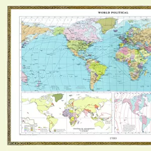
Map of the world showing British Empire possessions. Mary Evans Picture Library makes available wonderful images created for people to enjoy over the centuries. © Mary Evans Picture Library 2015 - https://copyrighthub.org/s0/hub1/creation/maryevans/MaryEvansPictureID/10039195

Media ID 585188

1897 Colonialism Imperialism Possessions

FEATURES IN THESE COLLECTIONS

> Maps and Charts > British Empire Maps

> Maps and Charts > Early Maps

> Maps and Charts > Related Images

> Maps and Charts > World

> Mary Evans Prints Online > Maps

> Popular Themes > Politics

SECURE PAYMENTS
We happily accept a wide range of payment options so you can pay for the things you need in the way that is most convenient for you

MADE IN AUSTRALIA
Safe Shipping with 30 Day Money Back Guarantee

FREE PERSONALISATION
We are proud to offer a range of customisation including Cropping, Captions, and Filters. Zoom Cropping can be adjusted in the Basket.


EDITORS COMMENTS

This stunning print of a world map from 1897 offers a fascinating glimpse into the era of imperialism and colonialism. The map vividly displays the vast extent of the British Empire's possessions at the height of its power, showcasing territories spread across continents and oceans. Each shaded region on the map represents an area under British control, highlighting the global reach and influence of this once mighty empire. From India to Africa to Australia, the British Empire's presence is unmistakable, with each possession symbolizing a complex history of conquest, exploitation, and cultural exchange. As we study this historical map, we are reminded of the political dynamics that shaped our modern world. The lines drawn on this map reflect not just geographical boundaries but also centuries-old power struggles and conflicts between nations. It serves as a visual reminder of how imperialism reshaped societies and landscapes around the globe. This print is not just a decorative piece but also a valuable educational tool for understanding our shared history. It prompts us to reflect on past injustices while also appreciating the interconnectedness of our world today. A truly captivating piece that invites viewers to explore both geography and politics through a historical lens.


Framed Prints

Step back in time with our captivating 'WORLD MAP / 1897' Framed Print from Mary Evans Picture Library. This vintage map, sourced from the prestigious Mary Evans Prints Online, beautifully illustrates the extent of the British Empire at the turn of the 20th century. The intricate detailing and rich colors of this historical map are showcased in our high-quality frames, making it a stunning addition to any room. Transport yourself to a bygone era and relive history with this unique and thought-provoking piece.


Photo Prints

Discover the rich history of the British Empire with our stunning "WORLD MAP / 1897" photographic print from Mary Evans Picture Library. This captivating image, available through Media Storehouse's extensive collection at Mary Evans Prints Online, offers a fascinating glimpse into the past. Depicting a world map from 1897, this print showcases the vast extent of the British Empire at the height of its influence. Add this historical and intriguing piece to your home or office decor, and transport yourself back in time. With premium print quality and attention to detail, our photographic prints make for a beautiful addition to any space. Experience the past like never before with Media Storehouse.


Poster Prints

Discover the rich history of the British Empire with our stunning "WORLD MAP / 1897" print from Mary Evans Picture Library. This captivating poster, available through Media Storehouse, showcases an intricately detailed map of the world as it existed in 1897, highlighting the extent of the British Empire's global reach. Transport yourself back in time as you explore the vast territories under British rule, making this print an essential addition to any history or geography enthusiast's collection. Order your "WORLD MAP / 1897" poster today and bring a piece of historical significance into your home or office.


Jigsaw Puzzles

Discover the rich history of the British Empire with our captivating jigsaw puzzle from the Media Storehouse collection. Featuring an intricately detailed World Map from the Mary Evans Picture Library, dated 1897, this puzzle offers an engaging and educational experience for all ages. Explore the expansive territories of the British Empire as it once existed, piecing together this stunning representation of geopolitical history. Immerse yourself in the intricacies of this puzzle and unveil the captivating story of a bygone era. Perfect for history enthusiasts, puzzle lovers, or anyone seeking a challenging and rewarding pastime.

diamond
Made With High Grade Materials
thumb_up
Professional Quality Finish
package_2
Carefully Packed To Aid Safe Arrival

You May Also Like


Atlantis / MapAtlantis / Map
Add to Basket
Maps / World / EratosthenesMaps / World / Eratosthenes
Add to Basket
Rangers Secure 2-0 Victory Over Partick Thistle: 17th April 2004Rangers Secure 2-0 Victory Over Partick Thistle: 17th April 2004
Add to Basket
Maps / Australia / New ZeaMaps / Australia / New Zea
Add to Basket
Mercator / World Map / 1587Mercator / World Map / 1587
Add to Basket
Map of St Pauls and areaMap of St Pauls and area
Add to Basket
World Known to PtolemyWorld Known to Ptolemy
Add to Basket
Map of Ancient GreeceMap of Ancient Greece
Add to Basket
Brown Bear KronheimBrown Bear Kronheim
Add to Basket
Advert / Frys ChocolateAdvert / Frys Chocolate
Add to Basket
Healless / Blackburn F balHealless / Blackburn F bal
Add to Basket
Greater Sandhill Cranes - in flight, coming in to winter roost at sunsetGreater Sandhill Cranes - in flight, coming in to winter roost at sunset
Add to Basket

Gallery Wall Inspiration

Map / Asia / India C1870
Map / Asia / India C1850
Map of Ancient Greece
World Map Empire McVitie
Maps / Australia / New Zea
Map / Europe / Germany 1871
Maps / World / Eratosthenes
Maps / Australia 1854
World Known to Ptolemy
Map / Europe / France / Paris
Map / Europe / Poland 1772
London Map 1560 / Aggas
Overton World Map / 1670
WORLD MAP / 1897
Map of St Pauls and area
Map / Europe / Greece / Ford
Map /s America / Brazil 16C
Maps / Americas 1540
Maps / World / Ptolemy 2Ad
Mercator / World Map / 1587
Map / Britain / Saxon Period
Atlantis / Map
Map / Russia / Siberia 1764
Map / China / Tibet 1749
Map / Europe / Germany 1827
Map / England & Wales 1810
Map / England & Wales 9C

Discover Our Collections


MapsMaps
View Collection
British Empire MapsBritish Empire Maps
View Collection
Early MapsEarly Maps
View Collection
PoliticsPolitics
View Collection
Maps and Charts Related ImagesMaps and Charts Related Images
View Collection
WorldWorld
View Collection


© Copyright Media Storehouse, All Rights Reserved 2003 - 2024
Facebook     Pinterest     Card Payments     Reviews IO