Home > South America > Guyana > Maps
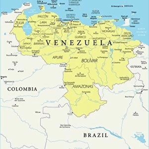
Map of Venezuela

![]()
Wall Art and Photo Gifts from Mary Evans Picture Library
Map of Venezuela
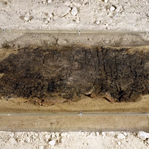
Venezuela - British Guiana (now Guyana) Boundary survey, Wenamu to Roraima, May 1904 Date: 1904
Mary Evans Picture Library makes available wonderful images created for people to enjoy over the centuries
Media ID 7401073
© Mary Evans Picture Library 2015 - https://copyrighthub.org/s0/hub1/creation/maryevans/MaryEvansPictureID/10473834
FEATURES IN THESE COLLECTIONS
> Mary Evans Prints Online
> National Archives
> South America
> Guyana
> Maps
> South America
> Venezuela
> Maps
EDITORS COMMENTS
1. Title: "Exploring the Uncharted Terrains: A Historical Look at the British Guiana (Guyana) and Venezuela Border Survey, 1904" This map print, dated 1904, showcases the intricate details of the border survey conducted between British Guiana (now Guyana) and Venezuela. The survey, which took place from Wenamamu to Roraima, is a testament to the exploratory spirit and cartographic advancements of the early 20th century. The map, with its rich topographical features and meticulous border demarcations, offers a glimpse into the complex geopolitical landscape of South America during a time when the exploration and mapping of territories were crucial for establishing sovereignty and fostering international relations. The map's vibrant colors and clear labeling make it an engaging visual representation of the region's geography, with the vast expanses of the Amazon rainforest, the winding rivers, and the towering peaks of the Roraima plateau all prominently featured. The survey, which was carried out by a team of skilled cartographers and explorers, was a significant achievement in the history of border demarcation. The intricate details of the map reflect the painstaking efforts of the surveyors to accurately chart the region's borders, ensuring that the territorial claims of both Venezuela and British Guiana were clearly defined. This map print, with its historical significance and captivating visual appeal, serves as a reminder of the rich cartographic heritage of South America and the important role that exploration and mapping played in shaping the region's political landscape. It is a fascinating window into the past, offering insights into the exploratory spirit, cartographic advancements, and geopolitical complexities of a bygone era.
MADE IN AUSTRALIA
Safe Shipping with 30 Day Money Back Guarantee
FREE PERSONALISATION*
We are proud to offer a range of customisation features including Personalised Captions, Color Filters and Picture Zoom Tools
SECURE PAYMENTS
We happily accept a wide range of payment options so you can pay for the things you need in the way that is most convenient for you
* Options may vary by product and licensing agreement. Zoomed Pictures can be adjusted in the Cart.