Home > Europe > United Kingdom > England > Hampshire > Littleton
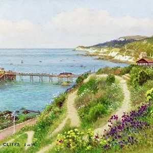
Sketch plan map of Ventnor, Isle of Wight, Hampshire. Date: circa 1910s

![]()
Wall Art and Photo Gifts from Mary Evans Picture Library
Sketch plan map of Ventnor, Isle of Wight, Hampshire. Date: circa 1910s
Mary Evans Picture Library makes available wonderful images created for people to enjoy over the centuries
Media ID 23431388
© Mary Evans / Grenville Collins Postcard Collection
Boniface Cliff Course Golf Hampshire Isle Littleton Pavilion Pier Plan Roads Ventnor Wight
FEATURES IN THESE COLLECTIONS
> Europe
> United Kingdom
> England
> Hampshire
> Littleton
> Europe
> United Kingdom
> England
> Isle of Wight
> Ventnor
> Mary Evans Prints Online
> New Images August 2021
> Transportation
> Trains
EDITORS COMMENTS
1. Title: A Glimpse of Ventnor, Isle of Wight: A Sketch Plan Map from the 1910s This sketch plan map, dated circa 1910s, offers a fascinating glimpse into the layout of the coastal resort town of Ventnor on the Isle of Wight, Hampshire, England. The map showcases an intricate and detailed representation of the town's streets, roads, and key landmarks, providing a window into its rich history. Ventnor, nestled on the southeastern coast of the Isle of Wight, was a popular holiday destination during the late 19th and early 20th centuries. This map highlights the town's main streets, such as St. Boniface Down, Rew, Littleton, West, and the bustling High Street. The map also reveals the presence of the Royal Victoria Pier, a prominent feature of Ventnor's waterfront, which served as a hub for leisure activities and transportation. The map also features several notable landmarks, including the Ventnor Railway Station, which connected the town to the mainland and other parts of the island. The town's pavilion, a popular gathering place for residents and visitors alike, is also depicted. Additionally, the map reveals the location of the St. Boniface Down Golf Course, a picturesque green expanse that offered visitors a chance to enjoy the beautiful scenery and engage in a friendly game of golf. The map also includes the Ventnor Beach and Cliff, which provided breathtaking views of the English Channel and served as a popular destination for sunbathing, swimming, and picnicking. The map's intricate details and charming aesthetic offer a glimpse into the past, providing a fascinating look at Ventnor's rich history and the experiences of its residents and visitors during the 1910s.
MADE IN AUSTRALIA
Safe Shipping with 30 Day Money Back Guarantee
FREE PERSONALISATION*
We are proud to offer a range of customisation features including Personalised Captions, Color Filters and Picture Zoom Tools
SECURE PAYMENTS
We happily accept a wide range of payment options so you can pay for the things you need in the way that is most convenient for you
* Options may vary by product and licensing agreement. Zoomed Pictures can be adjusted in the Cart.