Home > Europe > Italy > Sicily > Messina
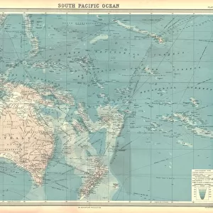
Portolan Atlas, 1587. Map which depicts a piece

![]()
Wall Art and Photo Gifts from Mary Evans Picture Library
Portolan Atlas, 1587. Map which depicts a piece
Portolan Atlas, 1587. Map which depicts a piece of land from India to the Himalayas, from Sulawesi to Papua New Guinea. Drawn in Messina. Facsimil. Miniature Painting. SPAIN. Madrid. National Library
Mary Evans Picture Library makes available wonderful images created for people to enjoy over the centuries
Media ID 8278735
© Mary Evans Picture Library 2015 - https://copyrighthub.org/s0/hub1/creation/maryevans/MaryEvansPictureID/10683220
Atlas Depicts Drawn Guinea Himalayas Illuminated Manuscript Manuscripts Messina Papua Piece Portolan Sulawesi
FEATURES IN THESE COLLECTIONS
> Europe
> Italy
> Sicily
> Messina
> Maps and Charts
> India
> Maps and Charts
> Spain
> Oceania
> Papua New Guinea
> Maps
EDITORS COMMENTS
This image showcases a fragment from the Portolan Atlas, a historic cartographic masterpiece created in Messina, Italy, in 1587. The intricately detailed map depicts a significant portion of the Asian continent, extending from the Indian subcontinent to the Himalayas, and encompassing the islands of Sulawesi and Papua New Guinea. This magnificent work of art was produced during the Spanish Rule in the Kingdom of Naples and Sicily. The Portolan Atlas is renowned for its distinctive style, characterized by its use of rhumb lines, which facilitated navigation along these lines, and its vivid, illuminated manuscript presentation. This particular map is a facsimile of the original, now preserved in the National Library of Spain, in Madrid. The meticulous miniature painting showcases the cartographer's exceptional skill and the advanced knowledge of the geography of the region during that time. The map's intricate details reveal the extensive maritime and land exploration that had taken place during the 16th century, as European powers sought to expand their territories and trade networks. The Portolan Atlas stands as a testament to the remarkable achievements of cartography during this period, providing valuable insights into the geographical understanding of the world at the time. This image offers a glimpse into the rich history of cartography and the fascinating exploration of the Asian continent during the Age of Discovery. The intricacies of the map, with its vibrant colors and detailed illustrations, continue to captivate and inspire scholars, historians, and cartography enthusiasts alike.
MADE IN AUSTRALIA
Safe Shipping with 30 Day Money Back Guarantee
FREE PERSONALISATION*
We are proud to offer a range of customisation features including Personalised Captions, Color Filters and Picture Zoom Tools
SECURE PAYMENTS
We happily accept a wide range of payment options so you can pay for the things you need in the way that is most convenient for you
* Options may vary by product and licensing agreement. Zoomed Pictures can be adjusted in the Cart.