Metal Print > Maps and Charts > Early Maps
Metal Print : Map Europe European 1930's 20th Century Country


![]()
Metal Prints from Design Pics
Map Europe European 1930's 20th Century Country
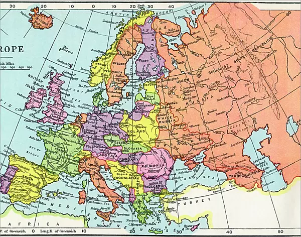
Map of Europe in the 1930's. From The Wonderland of Knowledge, published c.1930
Design Pics offers Distinctively Different Imagery representing over 1,500 contributors
Media ID 31611655
© Hilary Morgan
1930s 20th Century Countries Geographical Geogrpahy
14"x11" (28x35cm) Metal Print
Step back in time with our stunning Media Storehouse Metal Print featuring a vintage map of Europe from the 1930's. This captivating design, sourced from The Wonderland of Knowledge, published around 1930, showcases the European continent as it looked during the 20th century's intriguing and historic decade. The intricate details of Hilary Morgan's Map Europe are beautifully brought to life through our premium metal print process, creating a unique and timeless piece of art for your home or office. The vivid colors and exceptional clarity will draw the eye and spark conversation, making it an excellent addition to any decor. Elevate your space with a touch of history and elegance – order your Media Storehouse Metal Print today.
Our Metal Prints feature rounded corners and rear fixings for easy wall mounting. Images are directly printed onto a lightweight, high quality 5mm thick, durable metallic surface for a vivid and vibrant finish. Available in 2 sizes, 28x35cm (14x11) and 50x40cm (20x16). The unique material is fade, moisture, chemical and scratch resistant to help ensure this art lasts a lifetime.
Made with durable metal and luxurious printing techniques, metal prints bring images to life and add a modern touch to any space
Estimated Product Size is 35.5cm x 27.9cm (14" x 11")
These are individually made so all sizes are approximate
Artwork printed orientated as per the preview above, with landscape (horizontal) or portrait (vertical) orientation to match the source image.
FEATURES IN THESE COLLECTIONS
> Maps and Charts
> Early Maps
> Maps and Charts
> Related Images
EDITORS COMMENTS
This print takes us back in time to the 1930s, offering a glimpse into the geopolitical landscape of Europe during that era. The Map of Europe featured here is sourced from "The Wonderland of Knowledge" a publication dating back to approximately 1930. With its intricate engravings and vibrant colors, this archival piece showcases the geographical boundaries and divisions that shaped European countries during this pivotal period in history. As we examine this vintage illustration, it becomes evident how much has changed since then. Borders have shifted, nations have risen and fallen, and new alliances have been forged. This map serves as a reminder of the ever-evolving nature of our world. Beyond its historical significance, Hilary Morgan's expertly captured photograph allows us to appreciate the artistry involved in creating such maps during that time. The attention to detail is remarkable; every line meticulously drawn, every color carefully chosen. Whether you are an avid historian or simply intrigued by vintage aesthetics, this print will transport you to an era long gone but not forgotten. It invites contemplation on how geography shapes politics and cultures while serving as a testament to human curiosity about our place in the world
MADE IN AUSTRALIA
Safe Shipping with 30 Day Money Back Guarantee
FREE PERSONALISATION*
We are proud to offer a range of customisation features including Personalised Captions, Color Filters and Picture Zoom Tools
SECURE PAYMENTS
We happily accept a wide range of payment options so you can pay for the things you need in the way that is most convenient for you
* Options may vary by product and licensing agreement. Zoomed Pictures can be adjusted in the Cart.