Metal Print > Historic > Ancient civilizations > Roman Empire > Roman art
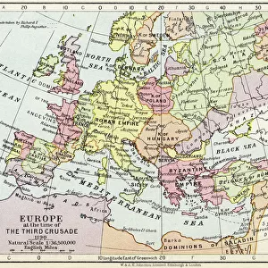
Metal Print : Map Of The Roman Empire In Ad 117 From The National Encyclopaedia Published By William Mackenzie London Late 19Th Century


![]()
Metal Prints from Design Pics
Map Of The Roman Empire In Ad 117 From The National Encyclopaedia Published By William Mackenzie London Late 19Th Century
Design Pics offers Distinctively Different Imagery representing over 1,500 contributors
Media ID 18188927
© Ken Welsh / Design Pics
10"x8" (25x20cm) Table Top Metal Print
Step back in time with our stunning Metal Print of the Map of the Roman Empire in AD 117, taken from the National Encyclopaedia published by William Mackenzie in London during the late 19th century. This captivating historical map, expertly captured by Ken Welsh from Design Pics, is now transformed into a contemporary work of art with our high-quality Metal Print. The intricate details of the Roman Empire's vast territories are brought to life through the unique textured finish of the metal, creating a visually striking and conversation-starting piece for your home or office. Add a touch of history and sophistication to any space with this beautiful and authentic reproduction.
Table Top Metal Prints feature rounded corners and an easel back for easy display. Available in two sizes, 18x13cm (7x5) or 25x20cm (10x8). Lightweight and vibrant, they are perfect for displaying artwork and are guaranteed to add style to any desk or table top. The unique material is fade, moisture, chemical and scratch resistant to help ensure this art lasts a lifetime.
Made with durable metal and luxurious printing techniques, metal prints bring images to life and add a modern touch to any space
Estimated Product Size is 25.4cm x 20.3cm (10" x 8")
These are individually made so all sizes are approximate
Artwork printed orientated as per the preview above, with landscape (horizontal) or portrait (vertical) orientation to match the source image.
FEATURES IN THESE COLLECTIONS
> Historic
> Ancient civilizations
> Roman Empire
> Roman art
> Maps and Charts
> Related Images
EDITORS COMMENTS
This print showcases a remarkable piece of history - the Map of the Roman Empire in AD 117. Published by William Mackenzie in late 19th century London, this exquisite engraving offers an intricate depiction of one of the greatest empires to ever exist. The map, presented horizontally and bursting with vibrant colors, takes us on a journey back in time to the height of Roman power and influence. Every detail is meticulously illustrated, capturing the vast expanse and territorial boundaries that spanned across Europe, Africa, and Asia during this period. As we study this fascinating artwork by Ken Welsh from Design Pics, we are transported into an era where mighty legions marched across continents and magnificent cities flourished under Roman rule. The precision and craftsmanship evident in every stroke remind us of the immense skill required to create such a masterpiece. This particular print holds great historical significance as it originated from the National Encyclopaedia - a testament to its authenticity and accuracy. It serves as both an educational tool for scholars seeking knowledge about ancient civilizations and a visual delight for anyone fascinated by our shared past. Ken Welsh's photograph allows us to appreciate not only the grandeur of Rome but also highlights how art can preserve history for generations to come. This stunning representation invites us to explore further into this empire that has left an indelible mark on human civilization.
MADE IN AUSTRALIA
Safe Shipping with 30 Day Money Back Guarantee
FREE PERSONALISATION*
We are proud to offer a range of customisation features including Personalised Captions, Color Filters and Picture Zoom Tools
SECURE PAYMENTS
We happily accept a wide range of payment options so you can pay for the things you need in the way that is most convenient for you
* Options may vary by product and licensing agreement. Zoomed Pictures can be adjusted in the Cart.