Metal Print > Europe > France > Paris > Maps
Metal Print : Map of Canada, published Paris, 1703 (hand-coloured engraving)
")


![]()
Metal Prints from Fine Art Finder
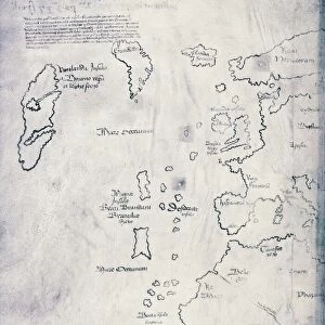
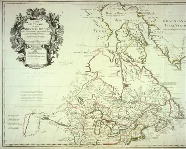
Map of Canada, published Paris, 1703 (hand-coloured engraving)
NBY332310 Map of Canada, published Paris, 1703 (hand-coloured engraving) by Delisle, Guillaume (1675-1726) (after); 50x65 cm; Newberry Library, Chicago, Illinois, USA; (add.info.: Carte du Canada ou de la Nouvelle France et des descouvertes qui y ont ete faites; ); eNewberry Library; French, out of copyright
Media ID 23378118
© Newberry Library / Bridgeman Images
Arctic Region Cartouche Discoveries Greenland Hudson Bay Labrador Mapping America Continent Baffin Bay Canadians Guillaume De Lisle
10"x8" (25x20cm) Table Top Metal Print
Add a touch of historical charm to your space with our exquisite Metal Print of a rare and captivating Map of Canada, published in Paris in 1703. This beautiful hand-coloured engraving, created by Guillaume Delisle after, showcases intricate detail and vibrant colours. With its rich history, this stunning piece from Bridgeman Images through Fine Art Finder is not just a map, but a window into the past. Bring this piece of history into your home or office and let it tell a story with every glance.
Table Top Metal Prints feature rounded corners and an easel back for easy display. Available in two sizes, 18x13cm (7x5) or 25x20cm (10x8). Lightweight and vibrant, they are perfect for displaying artwork and are guaranteed to add style to any desk or table top. The unique material is fade, moisture, chemical and scratch resistant to help ensure this art lasts a lifetime.
Made with durable metal and luxurious printing techniques, metal prints bring images to life and add a modern touch to any space
Estimated Product Size is 25.4cm x 20.3cm (10" x 8")
These are individually made so all sizes are approximate
Artwork printed orientated as per the preview above, with landscape (horizontal) or portrait (vertical) orientation to match the source image.
FEATURES IN THESE COLLECTIONS
> Fine Art Finder
> America & American Art (+canada)
> Fine Art Finder
> Artists
> American School
> Fine Art Finder
> Artists
> Guillaume (after) Delisle
> Europe
> France
> Paris
> Maps
> Europe
> United Kingdom
> Scotland
> Western Isles
> Related Images
> North America
> Canada
> Maps
> North America
> Canada
> Related Images
> North America
> Greenland
> Maps
> North America
> Greenland
> Related Images
> North America
> United States of America
> Illinois
> Chicago
EDITORS COMMENTS
This hand-coloured engraving, titled "Map of Canada, published Paris, 1703" takes us back in time to the early exploration and discovery of North America. Created by Guillaume Delisle, a renowned French cartographer of the 17th century, this map showcases his meticulous attention to detail and dedication to accuracy. Measuring at an impressive size of 50x65 cm, this print is housed in the prestigious Newberry Library in Chicago. Its historical significance lies not only in its depiction of Canada but also in its portrayal of the entire Western Hemisphere. From Baffin Bay to Hudson Bay and from Greenland to Labrador, every corner is meticulously illustrated. The intricate cartouche adorning the map adds a touch of elegance and grandeur. It serves as a testament to Delisle's artistry while providing valuable information about Canadian discoveries during that era. As we gaze upon this piece, we are transported back centuries ago when explorers braved unknown territories with curiosity and determination. The map reminds us of their remarkable achievements and contributions towards our understanding of geography. With its vibrant colors and precise engravings, this print captures both the beauty and importance of cartography as a means for documenting history. It stands as a timeless reminder that maps hold within them stories waiting to be discovered by those who seek knowledge about our past.
MADE IN AUSTRALIA
Safe Shipping with 30 Day Money Back Guarantee
FREE PERSONALISATION*
We are proud to offer a range of customisation features including Personalised Captions, Color Filters and Picture Zoom Tools
SECURE PAYMENTS
We happily accept a wide range of payment options so you can pay for the things you need in the way that is most convenient for you
* Options may vary by product and licensing agreement. Zoomed Pictures can be adjusted in the Cart.