Metal Print > North America > United States of America > New York > New York > Maps
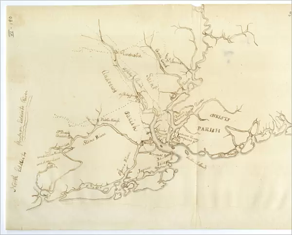
Metal Print : Map of Charleston, South Carolina, 3 August 1781 (litho)
")


![]()
Metal Prints from Fine Art Finder
Map of Charleston, South Carolina, 3 August 1781 (litho)
696027 Map of Charleston, South Carolina, 3 August 1781 (litho) by Lincoln, Benjamin (1733-1810); 32.6x19.7 cm; Gilder Lehrman Collection, New York, USA; (add.info.: Manuscript map of Charleston, South Carolina showing the coastline, various rivers and geographic features, certain structures and county names. Date and creator inferred, based on the presumption that this map accompanies GLC02437.01112.); eGilder Lehrman Institute of American History; American, out of copyright
Media ID 22618606
© Gilder Lehrman Institute of American History / Bridgeman Images
American Revolution Charleston Mapping South Carolina The War For Independence
10"x8" (25x20cm) Table Top Metal Print
Bring history to life with our stunning Metal Prints featuring the Map of Charleston, South Carolina, from 3 August 1781. This intricately detailed lithograph, sourced from Bridgeman Images through Fine Art Finder, showcases the strategic layout of Charleston during a pivotal moment in American history. The metal print's vibrant colors and high-definition image quality bring out the rich textures and nuances of this historic map. Add this unique piece to your home or office decor and transport yourself back in time. Perfect for history enthusiasts and collectors alike.
Table Top Metal Prints feature rounded corners and an easel back for easy display. Available in two sizes, 18x13cm (7x5) or 25x20cm (10x8). Lightweight and vibrant, they are perfect for displaying artwork and are guaranteed to add style to any desk or table top. The unique material is fade, moisture, chemical and scratch resistant to help ensure this art lasts a lifetime.
Made with durable metal and luxurious printing techniques, metal prints bring images to life and add a modern touch to any space
Estimated Product Size is 25.4cm x 20.3cm (10" x 8")
These are individually made so all sizes are approximate
Artwork printed orientated as per the preview above, with landscape (horizontal) or portrait (vertical) orientation to match the source image.
FEATURES IN THESE COLLECTIONS
> Fine Art Finder
> Artists
> American School
> Fine Art Finder
> Maps (celestial & Terrestrial)
> Arts
> Landscape paintings
> Waterfall and river artworks
> River artworks
> Maps and Charts
> Related Images
> North America
> United States of America
> Maps
> North America
> United States of America
> New York
> New York
> Maps
> North America
> United States of America
> New York
> Related Images
> North America
> United States of America
> South Carolina
> Charleston
> North America
> United States of America
> South Carolina
> Related Images
> Services
> Royal Navy
> South America
> Related Images
EDITORS COMMENTS
This lithograph print showcases a historical treasure, the "Map of Charleston, South Carolina, 3 August 1781". With its intricate details and expert craftsmanship, this piece offers a glimpse into the past. Created by Benjamin Lincoln in the late 18th century, this map provides an invaluable depiction of Charleston's coastline, rivers, and geographic features. It also highlights significant structures and county names that were relevant during that era. The date and creator are inferred based on its presumed association with GLC02437.01112. The map transports us back to a pivotal time in American history - the War for Independence. It serves as a visual representation of the strategic importance of Charleston's harbor during this period. One can almost imagine naval vessels navigating through these waters as troops from both sides fought fiercely for control. With its delicate engravings and meticulous attention to detail, this litho captures the essence of cartography in the 18th century. Its significance lies not only in its artistic value but also in preserving our understanding of America's past. Displayed proudly within the Gilder Lehrman Collection at New York City's eGilder Lehrman Institute of American History, this print is a testament to our nation's rich heritage. As we gaze upon it today, we are reminded of those who came before us - their struggles, triumphs, and unwavering spirit that shaped our great nation.
MADE IN AUSTRALIA
Safe Shipping with 30 Day Money Back Guarantee
FREE PERSONALISATION*
We are proud to offer a range of customisation features including Personalised Captions, Color Filters and Picture Zoom Tools
SECURE PAYMENTS
We happily accept a wide range of payment options so you can pay for the things you need in the way that is most convenient for you
* Options may vary by product and licensing agreement. Zoomed Pictures can be adjusted in the Cart.