Metal Print > Europe > France > Paris > Maps
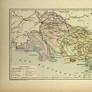
Metal Print : Plan of the departments of Arles, 1789 (coloured engraving)
")


![]()
Metal Prints from Fine Art Finder
Plan of the departments of Arles, 1789 (coloured engraving)
ARH214154 Plan of the departments of Arles, 1789 (coloured engraving) by French School, (18th century); Centre Historique des Archives Nationales, Paris, France; eCentre Historique des Archives Nationales; eArchives Charmet; French, out of copyright
Media ID 22658462
© Centre Historique des Archives Nationales Archives Charmet / Bridgeman Images
Languedoc Mediterranean Coast Provence South Of France
14"x11" (28x35cm) Metal Print
Bring a piece of historical art into your home with our Media Storehouse Metal Prints. This stunning coloured engraving, Plan of the Departments of Arles, 1789, by the French School, offers a captivating glimpse into the past. Originally from Centre Historique des Archives Nationales in Paris, this intricately detailed image showcases the architectural layout of Arles during the 18th century. Our high-quality metal prints are known for their vibrant colours, rich textures, and long-lasting durability. Transform any space into a gallery with this beautiful and historically significant work of art.
Our Metal Prints feature rounded corners and rear fixings for easy wall mounting. Images are directly printed onto a lightweight, high quality 5mm thick, durable metallic surface for a vivid and vibrant finish. Available in 2 sizes, 28x35cm (14x11) and 50x40cm (20x16). The unique material is fade, moisture, chemical and scratch resistant to help ensure this art lasts a lifetime.
Made with durable metal and luxurious printing techniques, metal prints bring images to life and add a modern touch to any space
Estimated Product Size is 35.5cm x 27.9cm (14" x 11")
These are individually made so all sizes are approximate
Artwork printed orientated as per the preview above, with landscape (horizontal) or portrait (vertical) orientation to match the source image.
FEATURES IN THESE COLLECTIONS
> Fine Art Finder
> Artists
> French School
> Fine Art Finder
> Maps (celestial & Terrestrial)
> Europe
> France
> Paris
> Maps
> Europe
> France
> Paris
> Related Images
> Maps and Charts
> Related Images
EDITORS COMMENTS
This coloured engraving titled "Plan of the departments of Arles, 1789" takes us back to 18th century France. The intricate details and vibrant colors bring to life the historical significance of this map. Located in the Centre Historique des Archives Nationales in Paris, France, this print showcases the coastal region of Arles along the Mediterranean coast. The map highlights not only the geographical layout but also provides insight into the administrative divisions during that time period. It offers a glimpse into how society was structured and organized within these departments. As we gaze upon this piece, our imagination transports us to a bygone era where trade routes flourished along Provence and Languedoc regions. We can almost envision bustling markets filled with merchants selling their wares and ships sailing across azure waters. This engraving is a testament to both artistic skill and historical documentation. It serves as a valuable resource for researchers, historians, or anyone interested in exploring the rich heritage of southern France. With its meticulous attention to detail and vivid coloring, this print from Bridgeman Images captures an important moment in history while reminding us of the enduring beauty found within cartography.
MADE IN AUSTRALIA
Safe Shipping with 30 Day Money Back Guarantee
FREE PERSONALISATION*
We are proud to offer a range of customisation features including Personalised Captions, Color Filters and Picture Zoom Tools
SECURE PAYMENTS
We happily accept a wide range of payment options so you can pay for the things you need in the way that is most convenient for you
* Options may vary by product and licensing agreement. Zoomed Pictures can be adjusted in the Cart.