Metal Print > Historic > Battles > Battle of Waterloo > Military strategy
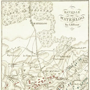
Metal Print : Plan of the Waterloo Campaign, June 16-18, 1815. From Historical Atlas, published 1923


![]()
Metal Prints From Fine Art Finder
Plan of the Waterloo Campaign, June 16-18, 1815. From Historical Atlas, published 1923
2603478 Plan of the Waterloo Campaign, June 16-18, 1815. From Historical Atlas, published 1923
Media ID 38504778
© Bridgeman Images
1815 Chart Coalition June Military Strategy Napoleonic Napoleonic Battle Napoleonic Conquest Napoleonic War Napoleonic Wars Positions Seventh Strategy Tactics War Strategy Wars Waterloo Battle Field Belgians Belgium Belgian
10"x8" (25x20cm) Table Top Metal Print
Step into history with our Metal Prints featuring stunning maps like 'Plan of the Waterloo Campaign, June 16-18, 1815.' This detailed illustration from a vintage atlas brings to life one of the most pivotal moments in European warfare. Printed on durable metal for a sleek and modern finish, this piece is perfect for historians and art lovers alike.
Table Top Metal Prints feature rounded corners and an easel back for easy display. Available in two sizes, 18x13cm (7x5) or 25x20cm (10x8). Lightweight and vibrant, they are perfect for displaying artwork and are guaranteed to add style to any desk or table top. The unique material is fade, moisture, chemical and scratch resistant to help ensure this art lasts a lifetime.
Made with durable metal and luxurious printing techniques, metal prints bring images to life and add a modern touch to any space
Estimated Product Size is 25.4cm x 20.3cm (10" x 8")
These are individually made so all sizes are approximate
Artwork printed orientated as per the preview above, with landscape (horizontal) or portrait (vertical) orientation to match the source image.
FEATURES IN THESE COLLECTIONS
> Europe
> Belgium
> Related Images
> Historic
> Battles
> Battle of Waterloo
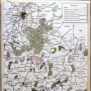
> Map of the Waterloo campaign
> Historic
> Battles
> Battle of Waterloo
> Military strategy
> Historic
> Battles
> Battle of Waterloo
> Strategy and planning
> Historic
> Battles
> Related Images
> Maps and Charts
> Early Maps
> Maps and Charts
> Related Images
EDITORS COMMENTS
This detailed and colorful print showcases the Plan of the Waterloo Campaign, which took place on June 16-18, 1815. Published in a Historical Atlas in 1923, this map provides a fascinating insight into the strategic military movements during this pivotal battle.
The Napoleonic Wars were a time of great conflict and upheaval in Europe, and this particular campaign was one of the most significant moments in history. The map highlights the positions of both sides as they prepared for battle, giving viewers a sense of the intensity and complexity of war strategy during this time.
Belgium served as the backdrop for this confrontation between Napoleon's forces and the coalition opposing him. The colors used in this print bring to life the chaos and drama of warfare, capturing the tension and high stakes involved in such battles.
As you study this map closely, you can almost imagine yourself standing on that battlefield centuries ago, witnessing firsthand the tactics employed by both sides. It serves as a reminder of how much our world has changed since then, yet also how some aspects of human nature remain constant throughout history.
Overall, this print is not just a historical artifact but also a testament to the enduring legacy of those who fought bravely on both sides during these turbulent times.
MADE IN AUSTRALIA
Safe Shipping with 30 Day Money Back Guarantee
FREE PERSONALISATION*
We are proud to offer a range of customisation features including Personalised Captions, Color Filters and Picture Zoom Tools
SECURE PAYMENTS
We happily accept a wide range of payment options so you can pay for the things you need in the way that is most convenient for you
* Options may vary by product and licensing agreement. Zoomed Pictures can be adjusted in the Basket.