Metal Print > Fine Art Finder > Schools > English School
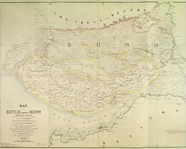
Metal Print : Map of Kutch and Runn, India, 1854 (colour litho)
")


Please select a smaller print size for this image
![]()
Metal Prints from Fine Art Finder
Map of Kutch and Runn, India, 1854 (colour litho)
XCF291092 Map of Kutch and Runn, India, 1854 (colour litho) by English School, (19th century); Private Collection; English, out of copyright
Media ID 12793561
© www.bridgemanart.com
British Empire British Raj Cutch Gulf Mapping Province Rann Region State Territory
10"x8" (25x20cm) Table Top Metal Print
Bring the historical beauty of the past into your modern home with our Media Storehouse Metal Prints. This exquisite piece features a vibrant color lithograph of the Map of Kutch and Runn, India, from 1854. Originally created by the English School during the 19th century, this out-of-copyright artwork from Fine Art Finder (XCF291092) showcases intricate detail and rich colors. Our high-quality metal prints are not only visually stunning but also durable and waterproof, making them perfect for any room in your house. Relive the history of India with this unique and captivating artwork.
Table Top Metal Prints feature rounded corners and an easel back for easy display. Available in two sizes, 18x13cm (7x5) or 25x20cm (10x8). Lightweight and vibrant, they are perfect for displaying artwork and are guaranteed to add style to any desk or table top. The unique material is fade, moisture, chemical and scratch resistant to help ensure this art lasts a lifetime.
Made with durable metal and luxurious printing techniques, metal prints bring images to life and add a modern touch to any space
Estimated Product Size is 25.4cm x 20.3cm (10" x 8")
These are individually made so all sizes are approximate
Artwork printed orientated as per the preview above, with landscape (horizontal) or portrait (vertical) orientation to match the source image.
EDITORS COMMENTS
This print takes us back to the year 1854, offering a glimpse into the rich history and intricate cartography of Kutch and Runn in India. With its vibrant colors brought to life through lithography, this map showcases the remarkable craftsmanship of the English School from the 19th century. The Map of Kutch and Runn transports us to a time when these regions were part of the vast British Empire. It highlights not only their geographical features but also serves as a testament to colonial expansion during that era. The detailed depiction allows us to explore various landmarks such as Cutch, Thull Desert, Gulf, Kattywar Province, and other significant areas within this Indian colony. As we delve into this historical artifact, it becomes evident that meticulous attention was given to every detail. From state boundaries to territorial divisions, each element contributes towards our understanding of how these regions fit within the broader context of Asia under British Raj rule. Beyond its aesthetic appeal lies an opportunity for exploration and discovery. This map invites us on a journey through time and space – an invitation extended by both geography enthusiasts and those seeking insight into India's colonial past. Displayed here is not just a piece of art but also a valuable educational tool that sheds light on an important chapter in world history. Let this image serve as a reminder that even in today's interconnected world, there is much we can learn from studying maps like these - symbols frozen in time yet still resonating with stories waiting to be told.
MADE IN AUSTRALIA
Safe Shipping with 30 Day Money Back Guarantee
FREE PERSONALISATION*
We are proud to offer a range of customisation features including Personalised Captions, Color Filters and Picture Zoom Tools
SECURE PAYMENTS
We happily accept a wide range of payment options so you can pay for the things you need in the way that is most convenient for you
* Options may vary by product and licensing agreement. Zoomed Pictures can be adjusted in the Cart.