Metal Print > Fine Art Storehouse > Map
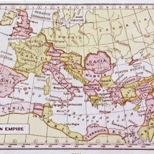
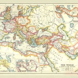
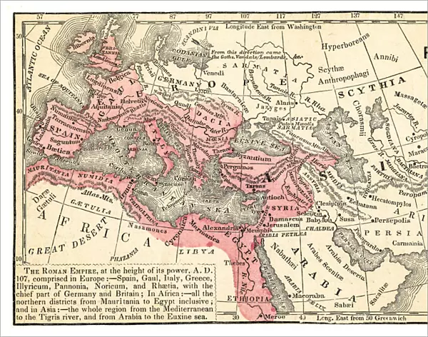
Metal Print : Roman empire map 1875


![]()
Metal Prints from Fine Art Storehouse
Roman empire map 1875
The Independent Course Comprehensive Geography by James Monteith, A.S. Barnes & Co, New York & Chicago 1875
Unleash your creativity and transform your space into a visual masterpiece!
THEPALMER
Media ID 13612221
© This content is subject to copyright
Britannia Byzantine Egypt Empire Middle East Roman Rome Byzantium Dacia Drawing Art Product
14"x11" (28x35cm) Metal Print
Step back in time with our exquisite Metal Print of the Roman Empire Map from THEPALMER's "The Independent Course in Geography" published in 1875. This detailed and intricately designed map transports you to the heart of the ancient world, showcasing the vast expanse of the Roman Empire in its prime. The high-quality Metal Print adds an elegant and modern touch to your decor, while preserving the historical accuracy and intricacy of the original map. Bring history to life in your home or office with this unique and captivating piece from Media Storehouse's Fine Art Collection.
Our Metal Prints feature rounded corners and rear fixings for easy wall mounting. Images are directly printed onto a lightweight, high quality 5mm thick, durable metallic surface for a vivid and vibrant finish. Available in 2 sizes, 28x35cm (14x11) and 50x40cm (20x16). The unique material is fade, moisture, chemical and scratch resistant to help ensure this art lasts a lifetime.
Made with durable metal and luxurious printing techniques, metal prints bring images to life and add a modern touch to any space
Estimated Product Size is 35.5cm x 27.9cm (14" x 11")
These are individually made so all sizes are approximate
Artwork printed orientated as per the preview above, with landscape (horizontal) or portrait (vertical) orientation to match the source image.
FEATURES IN THESE COLLECTIONS
> Fine Art Storehouse
> The Magical World of Illustration
> Palmer Illustrated Collection
> Fine Art Storehouse
> Map
> Historical Maps
EDITORS COMMENTS
This print showcases a historical gem, the "Roman Empire Map 1875" taken from James Monteith's renowned work, "The Independent Course Comprehensive Geography". Published in New York and Chicago by A. S. Barnes & Co. , this exquisite piece of art takes us on a visual journey through the vast territories once ruled by the mighty Roman Empire. With meticulous detail and precision, this horizontal illustration beautifully captures Britannia, Byzantium, Dacia, Egypt, Spain, and other significant regions that were part of this ancient empire. The intricate etching and engraving techniques used to create this masterpiece add depth and texture to every stroke. As we gaze upon this remarkable drawing art product by THEPALMER from Fine Art Storehouse, we are transported back in time to an era filled with grandeur and power. The map not only serves as a geographical representation but also provides valuable insights into the political boundaries of that period. From the Middle East to USA's eastern coastlines lies evidence of Rome's influence on civilization. This artwork is a testament to their expansionist ambitions and enduring legacy. It reminds us of how nature shaped these landscapes while simultaneously being transformed by human hands. Whether you're an avid history enthusiast or simply appreciate fine craftsmanship, this Roman Empire Map 1875 print is sure to captivate your imagination and transport you back in time to one of history's most influential empires - truly a treasure for any art collector or lover of antiquity.
MADE IN AUSTRALIA
Safe Shipping with 30 Day Money Back Guarantee
FREE PERSONALISATION*
We are proud to offer a range of customisation features including Personalised Captions, Color Filters and Picture Zoom Tools
SECURE PAYMENTS
We happily accept a wide range of payment options so you can pay for the things you need in the way that is most convenient for you
* Options may vary by product and licensing agreement. Zoomed Pictures can be adjusted in the Cart.