Metal Print > Africa > Eritrea > Maps
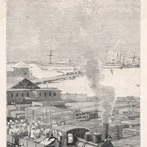
Metal Print : Historical map of Massawa and surroundings, Eritrea, woodcut, published 1897


![]()
Metal Prints from Fine Art Storehouse
Historical map of Massawa and surroundings, Eritrea, woodcut, published 1897
Historical map of Massawa and surroundings, Eritrea. Wood engraving, published in 1897
Unleash your creativity and transform your space into a visual masterpiece!
ZU_09
Media ID 18106949
14"x11" (28x35cm) Metal Print
Step back in time with our exquisite Historical Map of Massawa and Surroundings, Eritrea, from the Media Storehouse Metal Prints collection. This stunning woodcut, published in 1897 by ZU_09 from the Fine Art Storehouse, transports you to a bygone era with intricate detail and authenticity. Ideal for history enthusiasts, world travelers, or those who appreciate the beauty of vintage maps, this metal print adds a unique touch to any space. With its durable and waterproof finish, this Historical Map of Massawa and Surroundings is not only a work of art but also a long-lasting investment. Bring history to life in your home or office with this captivating piece from Media Storehouse.
Our Metal Prints feature rounded corners and rear fixings for easy wall mounting. Images are directly printed onto a lightweight, high quality 5mm thick, durable metallic surface for a vivid and vibrant finish. Available in 2 sizes, 28x35cm (14x11) and 50x40cm (20x16). The unique material is fade, moisture, chemical and scratch resistant to help ensure this art lasts a lifetime.
Made with durable metal and luxurious printing techniques, metal prints bring images to life and add a modern touch to any space
Estimated Product Size is 35.5cm x 27.9cm (14" x 11")
These are individually made so all sizes are approximate
Artwork printed orientated as per the preview above, with landscape (horizontal) or portrait (vertical) orientation to match the source image.
FEATURES IN THESE COLLECTIONS
> Fine Art Storehouse
> Map
> Historical Maps
> Africa
> Eritrea
> Related Images
> Maps and Charts
> Early Maps
> Maps and Charts
> Related Images
EDITORS COMMENTS
This print showcases a historical map of Massawa and its surroundings in Eritrea, beautifully captured through the intricate technique of woodcut. Published in 1897, this wood engraving offers a mesmerizing glimpse into the past, allowing us to delve into the rich history of this enchanting region. The map itself is a testament to the artistry and precision of its creator, ZU_09. Every detail has been meticulously etched onto the wooden surface, resulting in an exquisite piece that seamlessly blends cartography with artistic expression. The delicate lines and fine textures bring life to each landmark and street, inviting viewers to embark on a visual journey through time. Massawa's significance as an ancient port city is palpable within this artwork. It effortlessly captures the essence of a bustling hub where cultures converged and trade flourished for centuries. As we gaze upon this masterpiece, we are transported back to an era when Massawa was at its zenith – witnessing caravans arriving from distant lands while ships sailed across shimmering waters. Whether you have a personal connection to Eritrea or simply appreciate historical maps as works of art, this print will undoubtedly captivate your imagination. Let it adorn your walls as both a conversation starter and a reminder of our collective human heritage - one that deserves admiration and preservation for generations to come.
MADE IN AUSTRALIA
Safe Shipping with 30 Day Money Back Guarantee
FREE PERSONALISATION*
We are proud to offer a range of customisation features including Personalised Captions, Color Filters and Picture Zoom Tools
SECURE PAYMENTS
We happily accept a wide range of payment options so you can pay for the things you need in the way that is most convenient for you
* Options may vary by product and licensing agreement. Zoomed Pictures can be adjusted in the Cart.