Metal Print > Arts > Artists > J > Japanese School Japanese School
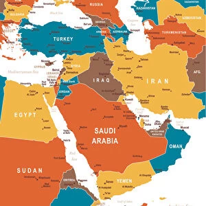
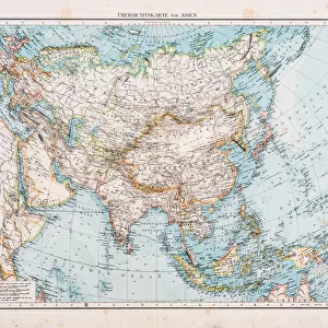
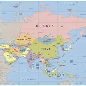
Metal Print : Map of Asia 1895


![]()
Metal Prints from Fine Art Storehouse
Map of Asia 1895
The Rand-McNally Grammar School Geography 1895 - Chicago & New York
Unleash your creativity and transform your space into a visual masterpiece!
THEPALMER
Media ID 14824639
© This content is subject to copyright
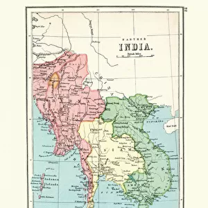
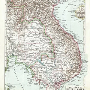
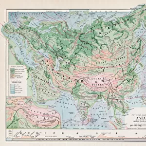
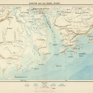
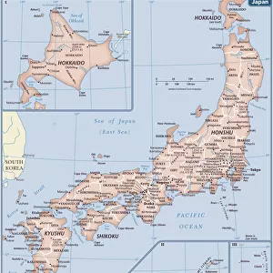
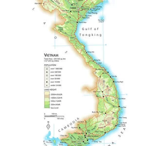
China East Asia India Indochina Japan Vietnam
10"x8" (25x20cm) Table Top Metal Print
Step back in time with our vintage Map of Asia 1895 from THEPALMER, available as a stunning Metal Print from Media Storehouse. This intricately detailed geographical representation is taken from the esteemed Rand-McNally Grammar School Geography 1895 publication, published in Chicago and New York. The Metal Print process beautifully enhances the colors and textures of this historical map, making it a captivating addition to any home or office decor. Travel back in time and explore the world's history with this unique and eye-catching piece of art. Order your Map of Asia 1895 Metal Print from Media Storehouse today.
Table Top Metal Prints feature rounded corners and an easel back for easy display. Available in two sizes, 18x13cm (7x5) or 25x20cm (10x8). Lightweight and vibrant, they are perfect for displaying artwork and are guaranteed to add style to any desk or table top. The unique material is fade, moisture, chemical and scratch resistant to help ensure this art lasts a lifetime.
Made with durable metal and luxurious printing techniques, metal prints bring images to life and add a modern touch to any space
Estimated Product Size is 25.4cm x 20.3cm (10" x 8")
These are individually made so all sizes are approximate
Artwork printed orientated as per the preview above, with landscape (horizontal) or portrait (vertical) orientation to match the source image.
FEATURES IN THESE COLLECTIONS
> Fine Art Storehouse
> Map
> Historical Maps
> Arts
> Artists
> J
> Japanese School Japanese School
> Asia
> India
> Related Images
> Asia
> Japan
> Related Images
> Asia
> Related Images
> Asia
> Vietnam
> Related Images
EDITORS COMMENTS
In this print titled "Map of Asia 1895" we are transported back in time to the late 19th century, where cartography was a true art form. The map, originally featured in "The Rand-McNally Grammar School Geography 1895" publication from Chicago and New York, offers us a glimpse into the intricate details of Asia's vast landscape. As our eyes wander across the image, we are immediately drawn to the richly illustrated regions that make up this diverse continent. From China's majestic Great Wall winding its way through mountains and valleys to India's vibrant tapestry of cultures and traditions, every corner tells a unique story waiting to be explored. The map also highlights Indochina's lush forests and rivers flowing gracefully through Vietnam's picturesque landscapes. Further eastward lies Japan, with its archipelago meticulously depicted along with its iconic Mount Fuji standing tall amidst serene surroundings. "The Map of Asia 1895" is not just an artistic representation; it serves as a historical document that captures the geopolitical boundaries during that era. It invites us to reflect on how much has changed over time while appreciating the enduring beauty of these ancient lands. With THEPALMER’s expert touch in preserving this piece of history through fine art printing techniques, this print becomes more than just an aesthetic addition to any space—it becomes a window into another world for those who gaze upon it.
MADE IN AUSTRALIA
Safe Shipping with 30 Day Money Back Guarantee
FREE PERSONALISATION*
We are proud to offer a range of customisation features including Personalised Captions, Color Filters and Picture Zoom Tools
SECURE PAYMENTS
We happily accept a wide range of payment options so you can pay for the things you need in the way that is most convenient for you
* Options may vary by product and licensing agreement. Zoomed Pictures can be adjusted in the Cart.