Metal Print > Europe > United Kingdom > England > Maps
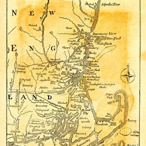
Metal Print : Map of New England in 1684, 17th Century


![]()
Metal Prints from Fine Art Storehouse
Map of New England in 1684, 17th Century
Vintage engraving of Map of New England in 1684, 17th Century
Unleash your creativity and transform your space into a visual masterpiece!
duncan1890
Media ID 18563420
© of Duncan P Walker
17th Century 17th Century Style
10"x8" (25x20cm) Table Top Metal Print
Step back in time with our exquisite Metal Print of a vintage engraving of a Map of New England from 1684. This intricately detailed 17th-century map, created by duncan1890 from the Fine Art Storehouse, showcases the early exploration and settlement of the New England region. The Map of New England Metal Print is beautifully crafted on high-quality metal, giving it a unique and modern look while preserving the historical charm of the original engraving. Add this captivating piece to your home or office to inspire a sense of history and adventure.
Table Top Metal Prints feature rounded corners and an easel back for easy display. Available in two sizes, 18x13cm (7x5) or 25x20cm (10x8). Lightweight and vibrant, they are perfect for displaying artwork and are guaranteed to add style to any desk or table top. The unique material is fade, moisture, chemical and scratch resistant to help ensure this art lasts a lifetime.
Made with durable metal and luxurious printing techniques, metal prints bring images to life and add a modern touch to any space
Estimated Product Size is 25.4cm x 20.3cm (10" x 8")
These are individually made so all sizes are approximate
Artwork printed orientated as per the preview above, with landscape (horizontal) or portrait (vertical) orientation to match the source image.
FEATURES IN THESE COLLECTIONS
> Fine Art Storehouse
> Map
> Historical Maps
> Europe
> United Kingdom
> England
> Maps
> Europe
> United Kingdom
> England
> Posters
> Europe
> United Kingdom
> England
> Related Images
> Maps and Charts
> Related Images
EDITORS COMMENTS
This vintage engraving takes us back in time to the 17th century, offering a glimpse into the intricate world of cartography. The Map of New England in 1684 showcases the artistry and precision that went into creating these historical navigational tools. Rendered in black and white, this antique print exudes an air of elegance and nostalgia. As we study this map, we are transported to a bygone era when exploration was at its peak. Every detail meticulously etched on paper tells a story of discovery and adventure. From the beautifully illustrated coastlines to the intricately labeled towns and rivers, it is evident that countless hours were dedicated to crafting this masterpiece. The map's monochromatic palette adds to its allure, allowing us to focus solely on the intricate details without any distractions. It serves as a reminder of how far we have come in terms of technological advancements while also instilling a sense of appreciation for the craftsmanship displayed during simpler times. Duncan1890's fine art print captures not only history but also our imagination. It invites us to delve deeper into New England's past, sparking curiosity about what life must have been like during those early colonial days. This piece is perfect for anyone with an interest in history or those who simply appreciate timeless beauty captured through skilled hands and keen eyesight.
MADE IN AUSTRALIA
Safe Shipping with 30 Day Money Back Guarantee
FREE PERSONALISATION*
We are proud to offer a range of customisation features including Personalised Captions, Color Filters and Picture Zoom Tools
SECURE PAYMENTS
We happily accept a wide range of payment options so you can pay for the things you need in the way that is most convenient for you
* Options may vary by product and licensing agreement. Zoomed Pictures can be adjusted in the Cart.