Metal Print > Europe > Germany > Maps
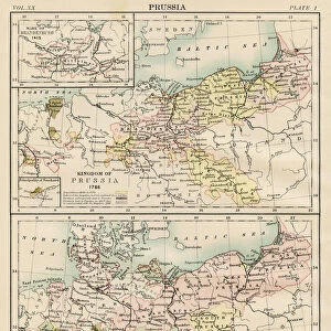
Metal Print : Map of Prussia (Germany), 1866 to 1918, litograph, published 1897
, 1866 to 1918, litograph, published 1897")


![]()
Metal Prints from Fine Art Storehouse
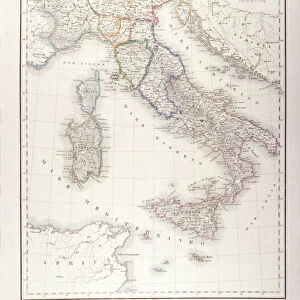
Map of Prussia (Germany), 1866 to 1918, litograph, published 1897
Map of the Prussian state in the German Empire with the largest expansion from 1866 to 1918. Lithograph, published in 1897
Unleash your creativity and transform your space into a visual masterpiece!
ZU_09
Media ID 18292259
14"x11" (28x35cm) Metal Print
Step back in time with our stunning Metal Print of the historic Map of Prussia, published in 1897 by ZU_09. This intricately detailed lithograph showcases the Prussian state's expansion from 1866 to 1918 within the German Empire. Each Metal Print is meticulously crafted, bringing the history and artistry of this vintage map to life. Experience the rich heritage of this period with our high-quality, vibrant, and long-lasting Metal Print. Perfect for history enthusiasts, collectors, or anyone who appreciates the beauty of historical cartography.
Our Metal Prints feature rounded corners and rear fixings for easy wall mounting. Images are directly printed onto a lightweight, high quality 5mm thick, durable metallic surface for a vivid and vibrant finish. Available in 2 sizes, 28x35cm (14x11) and 50x40cm (20x16). The unique material is fade, moisture, chemical and scratch resistant to help ensure this art lasts a lifetime.
Made with durable metal and luxurious printing techniques, metal prints bring images to life and add a modern touch to any space
Estimated Product Size is 35.5cm x 27.9cm (14" x 11")
These are individually made so all sizes are approximate
Artwork printed orientated as per the preview above, with landscape (horizontal) or portrait (vertical) orientation to match the source image.
FEATURES IN THESE COLLECTIONS
> Fine Art Storehouse
> Map
> Historical Maps
> Europe
> Germany
> Related Images
> Maps and Charts
> Related Images
EDITORS COMMENTS
This lithograph, titled "Map of Prussia (Germany), 1866 to 1918" takes us on a historical journey through the expansion and transformation of the Prussian state within the German Empire. Published in 1897 by ZU_09, this print offers a visual representation of one of Europe's most influential territories during a crucial period. The map showcases Prussia's remarkable growth from 1866 to 1918, capturing its territorial acquisitions and political developments. With intricate details and precise cartographic work, it provides an invaluable resource for historians and enthusiasts alike. As we delve into this artwork, our eyes are drawn to the vibrant colors that highlight each region within Prussia. The shades vary from deep blues representing established territories to lighter hues indicating newly acquired lands. This chromatic distinction emphasizes both continuity and change throughout these significant years. Beyond its aesthetic appeal, this lithograph serves as a testament to the power dynamics that shaped European history during the late nineteenth century. It invites us to reflect upon how geopolitical forces influenced borders and alliances in an era marked by rapid industrialization and shifting national identities. Whether displayed in a classroom or cherished as part of a personal collection, this print is not only visually striking but also intellectually stimulating. It encapsulates an important chapter in Germany's past while offering endless opportunities for exploration and discussion about political geography, historical context, and cultural heritage.
MADE IN AUSTRALIA
Safe Shipping with 30 Day Money Back Guarantee
FREE PERSONALISATION*
We are proud to offer a range of customisation features including Personalised Captions, Color Filters and Picture Zoom Tools
SECURE PAYMENTS
We happily accept a wide range of payment options so you can pay for the things you need in the way that is most convenient for you
* Options may vary by product and licensing agreement. Zoomed Pictures can be adjusted in the Cart.