Metal Print > Europe > United Kingdom > Scotland > Maps
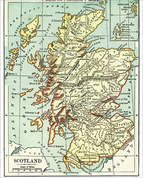
Metal Print : Map of Scotland 1889


![]()
Metal Prints from Fine Art Storehouse
Map of Scotland 1889
Comprehensive Geography by James Monteith - American Book Company 1882, 1889
Unleash your creativity and transform your space into a visual masterpiece!
THEPALMER
Media ID 18357297
10"x8" (25x20cm) Table Top Metal Print
Discover the rich history of Scotland with our stunning Metal Print of the Map of Scotland from 1889 by THEPALMER, available at Media Storehouse. This exquisite piece is derived from the Comprehensive Geography book published by the American Book Company in 1882 and 1889. The intricate details of the map are brought to life through our high-quality metal print process, creating a vibrant and durable piece that adds character and depth to any space. With its antique charm and captivating design, this Map of Scotland Metal Print is a must-have for history enthusiasts and those who appreciate the beauty of cartography. Order yours today and bring a piece of the past into your home or office.
Table Top Metal Prints feature rounded corners and an easel back for easy display. Available in two sizes, 18x13cm (7x5) or 25x20cm (10x8). Lightweight and vibrant, they are perfect for displaying artwork and are guaranteed to add style to any desk or table top. The unique material is fade, moisture, chemical and scratch resistant to help ensure this art lasts a lifetime.
Made with durable metal and luxurious printing techniques, metal prints bring images to life and add a modern touch to any space
Estimated Product Size is 20.3cm x 25.4cm (8" x 10")
These are individually made so all sizes are approximate
Artwork printed orientated as per the preview above, with landscape (horizontal) or portrait (vertical) orientation to match the source image.
FEATURES IN THESE COLLECTIONS
> Fine Art Storehouse
> Map
> Historical Maps
> Europe
> United Kingdom
> Scotland
> Maps
> Europe
> United Kingdom
> Scotland
> Posters
> Europe
> United Kingdom
> Scotland
> Related Images
> Maps and Charts
> Related Images
EDITORS COMMENTS
This print showcases a historical gem, the "Map of Scotland 1889" taken from James Monteith's renowned book "Comprehensive Geography". Published by the American Book Company in both 1882 and 1889, this map is a testament to the timeless allure of cartography. The intricate details etched on this vintage piece transport us back to an era when exploration and discovery were at their peak. The fine craftsmanship evident in every line and curve invites us to embark on a visual journey through Scotland's rich geography. From its majestic highlands adorned with rugged peaks, serene lochs, and winding rivers, to its picturesque lowlands dotted with charming towns and bustling cities - this map encapsulates the essence of Scotland. As we delve into this snapshot of history captured by THEPALMER for Fine Art Storehouse, we are reminded of how maps have always been more than just navigational tools; they are windows into our past. This particular print allows us to appreciate not only the beauty but also the significance of cartographic artistry as it was practiced over a century ago. Whether you're an avid historian or simply captivated by Scotland's enchanting landscapes, let this exquisite print take you on a mesmerizing voyage through time as you explore one of Europe's most captivating countries.
MADE IN AUSTRALIA
Safe Shipping with 30 Day Money Back Guarantee
FREE PERSONALISATION*
We are proud to offer a range of customisation features including Personalised Captions, Color Filters and Picture Zoom Tools
SECURE PAYMENTS
We happily accept a wide range of payment options so you can pay for the things you need in the way that is most convenient for you
* Options may vary by product and licensing agreement. Zoomed Pictures can be adjusted in the Cart.