Metal Print > Maps and Charts > Americas
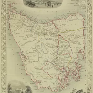
Metal Print : Map of Southern states1889


![]()
Metal Prints from Fine Art Storehouse
Map of Southern states1889
Comprehensive Geography by James Monteith - American Book Company 1882, 1889
Unleash your creativity and transform your space into a visual masterpiece!
THEPALMER
Media ID 18357247
10"x8" (25x20cm) Table Top Metal Print
Discover history through the captivating art of our Metal Prints. This exquisite piece showcases a vintage map of the Southern States from 1889, taken from "Comprehensive Geography" by James Monteith published by The American Book Company. The intricate details of the map are brought to life through the vibrant colors and high-quality finish of our Metal Print. Each print is meticulously crafted on a durable aluminum sheet, ensuring a long-lasting and eye-catching addition to your home or office decor. Transport yourself back in time and add a touch of history to your space with this stunning piece from the Media Storehouse Fine Art Collection.
Table Top Metal Prints feature rounded corners and an easel back for easy display. Available in two sizes, 18x13cm (7x5) or 25x20cm (10x8). Lightweight and vibrant, they are perfect for displaying artwork and are guaranteed to add style to any desk or table top. The unique material is fade, moisture, chemical and scratch resistant to help ensure this art lasts a lifetime.
Made with durable metal and luxurious printing techniques, metal prints bring images to life and add a modern touch to any space
Estimated Product Size is 25.4cm x 20.3cm (10" x 8")
These are individually made so all sizes are approximate
Artwork printed orientated as per the preview above, with landscape (horizontal) or portrait (vertical) orientation to match the source image.
FEATURES IN THESE COLLECTIONS
> Fine Art Storehouse
> Map
> Historical Maps
> Maps and Charts
> Related Images
EDITORS COMMENTS
In this print titled "Map of Southern States 1889" we are transported back in time to an era when cartography was both a science and an art form. The map, originally featured in James Monteith's Comprehensive Geography published by the American Book Company in 1882 and updated in 1889, offers us a glimpse into the intricate details of the southern region of the United States during that period. The rich colors and meticulous craftsmanship showcased in this print highlight the dedication and expertise required to create such comprehensive maps before modern technology simplified the process. Every contour, river, city, and state boundary is meticulously depicted with remarkable precision. As we explore this historical document through THEPALMER's lens, it becomes apparent that this map served as more than just a navigational tool; it encapsulated a snapshot of society at that time. It provides valuable insights into transportation networks, economic hubs, political boundaries, and even cultural nuances within each state. This particular print from Fine Art Storehouse allows us to appreciate not only its historical significance but also its aesthetic beauty. Whether displayed on office walls or cherished within personal collections, this piece serves as a reminder of our ever-evolving world while honoring the artistry behind traditional cartography.
MADE IN AUSTRALIA
Safe Shipping with 30 Day Money Back Guarantee
FREE PERSONALISATION*
We are proud to offer a range of customisation features including Personalised Captions, Color Filters and Picture Zoom Tools
SECURE PAYMENTS
We happily accept a wide range of payment options so you can pay for the things you need in the way that is most convenient for you
* Options may vary by product and licensing agreement. Zoomed Pictures can be adjusted in the Cart.