Metal Print > Maps and Charts > Early Maps
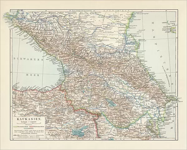
Metal Print : Topographic map of the Caucasus Region, lithograph, published in 1898


![]()
Metal Prints from Fine Art Storehouse
Topographic map of the Caucasus Region, lithograph, published in 1898
Historical topographic map of the Caucasus Region. Lithograph, published in 1898
Unleash your creativity and transform your space into a visual masterpiece!
ZU_09
Media ID 35842956
10"x8" (25x20cm) Table Top Metal Print
Step back in time with our exquisite Metal Print of a historical topographic map of the Caucasus Region. This beautiful lithograph, published in 1898 by ZU_09 from our Fine Art Storehouse collection, showcases intricate details of the geography of the Caucasus during that era. The vibrant colors and high-quality metal print finish bring out the intricacies of the topography, making it a stunning addition to any room. Relive history and add a touch of vintage charm to your decor with this unique piece from Media Storehouse.
Table Top Metal Prints feature rounded corners and an easel back for easy display. Available in two sizes, 18x13cm (7x5) or 25x20cm (10x8). Lightweight and vibrant, they are perfect for displaying artwork and are guaranteed to add style to any desk or table top. The unique material is fade, moisture, chemical and scratch resistant to help ensure this art lasts a lifetime.
Made with durable metal and luxurious printing techniques, metal prints bring images to life and add a modern touch to any space
Estimated Product Size is 25.4cm x 20.3cm (10" x 8")
These are individually made so all sizes are approximate
Artwork printed orientated as per the preview above, with landscape (horizontal) or portrait (vertical) orientation to match the source image.
FEATURES IN THESE COLLECTIONS
> Fine Art Storehouse
> Map
> Historical Maps
> Maps and Charts
> Early Maps
> Maps and Charts
> Related Images
EDITORS COMMENTS
This stunning topographic map of the Caucasus Region, published in 1898, offers a captivating glimpse into the geography and cartography of the past. The intricate lithograph, produced by an unknown cartographer, showcases the intricacies of the mountainous terrain that defines this historic and culturally rich area. The Caucasus Region, located at the intersection of Europe and Asia, has long been a crossroads of history and culture. This map provides a detailed and accurate representation of the region's topography during a time when exploration and cartography were advancing rapidly. The map includes not only the mountain ranges that dominate the landscape, such as the Great Caucasus and the Lesser Caucasus, but also the numerous rivers, lakes, and towns that dot the region. The intricate detail of the map is evident in the contour lines that delineate the mountains and the careful labeling of geographical features. The use of color to differentiate between various elevations adds an additional layer of depth and complexity. The map also includes a scale bar and a compass rose, making it a valuable tool for navigators and explorers of the time. This historical topographic map of the Caucasus Region is a testament to the skill and dedication of the cartographers of the late 19th century. It offers a fascinating glimpse into the past, allowing us to explore the geography and history of this remarkable region in a way that is both educational and aesthetically pleasing. Whether you are a history buff, a cartography enthusiast, or simply someone who appreciates the beauty of the natural world, this map is sure to captivate and inspire.
MADE IN AUSTRALIA
Safe Shipping with 30 Day Money Back Guarantee
FREE PERSONALISATION*
We are proud to offer a range of customisation features including Personalised Captions, Color Filters and Picture Zoom Tools
SECURE PAYMENTS
We happily accept a wide range of payment options so you can pay for the things you need in the way that is most convenient for you
* Options may vary by product and licensing agreement. Zoomed Pictures can be adjusted in the Cart.