Metal Print > North America > United States of America > Maps
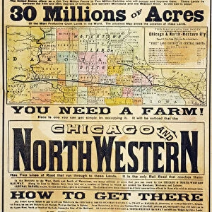
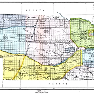
Metal Print : Dakota Missesota Nebraska map 1867


![]()
Metal Prints from Fine Art Storehouse
Dakota Missesota Nebraska map 1867
Mitchellas Modern Atlas - Published by E.H. Butler and Co - Philadelphia 1867
Unleash your creativity and transform your space into a visual masterpiece!
THEPALMER
Media ID 13609191
© This content is subject to copyright
Minnesota Nebraska North America Dakota
10"x8" (25x20cm) Table Top Metal Print
Step back in time with our stunning Metal Print of the Dakota Missesota Nebraska map from THEPALMER's Mitchell's Modern Atlas, published by E.H. Butler and Co in 1867. This vintage map of the Midwest region showcases intricate detail and historical accuracy, transporting you to a bygone era. Our high-quality Metal Print preserves the rich colors and textures of the original map, while the sleek metal finish adds a modern and sophisticated touch to any decor. Bring history into your home or office with this unique and captivating piece from Media Storehouse's Fine Art collection.
Table Top Metal Prints feature rounded corners and an easel back for easy display. Available in two sizes, 18x13cm (7x5) or 25x20cm (10x8). Lightweight and vibrant, they are perfect for displaying artwork and are guaranteed to add style to any desk or table top. The unique material is fade, moisture, chemical and scratch resistant to help ensure this art lasts a lifetime.
Made with durable metal and luxurious printing techniques, metal prints bring images to life and add a modern touch to any space
Estimated Product Size is 20.3cm x 25.4cm (8" x 10")
These are individually made so all sizes are approximate
Artwork printed orientated as per the preview above, with landscape (horizontal) or portrait (vertical) orientation to match the source image.
FEATURES IN THESE COLLECTIONS
> Fine Art Storehouse
> Map
> Historical Maps
> Fine Art Storehouse
> Map
> USA Maps
> Maps and Charts
> Related Images
> North America
> Related Images
> North America
> United States of America
> Illinois
> Related Images
> North America
> United States of America
> Maps
> North America
> United States of America
> Minnesota
> Related Images
> North America
> United States of America
> Nebraska
> Related Images
> North America
> United States of America
> North Dakota
> Related Images
EDITORS COMMENTS
This print takes us back in time to the year 1867, when the Dakota Missesota Nebraska map was first published in Mitchell's Modern Atlas by E. H. Butler and Co. The image showcases an exquisite piece of cartography that beautifully captures the intricacies of North America during that era. The map itself is a testament to the artistry and precision involved in creating physical geography representations before modern technology took over. Through detailed engraving and etching techniques, this antique lithograph brings forth a visual narrative of the region's topography, highlighting states like Dakota, Missesota (now known as Minnesota), Nebraska, Illinois, and more. As we gaze upon this vertical masterpiece, it becomes evident how much our world has transformed since then. It serves as a reminder of our ever-evolving landscapes and how history shapes our present reality. The illustration transports us to a time when exploration was paramount and maps were essential tools for understanding uncharted territories. "The Palmer" who captured this remarkable photograph at Fine Art Storehouse, skillfully preserves not only the historical significance but also the artistic beauty of this vintage map print. With its rich tones and intricate details brought to life through photography, it offers viewers an opportunity to appreciate both its aesthetic appeal and educational value. Whether you are an enthusiast of antique cartography or simply intrigued by glimpses into our past, this print invites you on a journey through time while celebrating the artistry behind these magnificent works from yesteryears.
MADE IN AUSTRALIA
Safe Shipping with 30 Day Money Back Guarantee
FREE PERSONALISATION*
We are proud to offer a range of customisation features including Personalised Captions, Color Filters and Picture Zoom Tools
SECURE PAYMENTS
We happily accept a wide range of payment options so you can pay for the things you need in the way that is most convenient for you
* Options may vary by product and licensing agreement. Zoomed Pictures can be adjusted in the Cart.