Metal Print > Fine Art Storehouse > Map
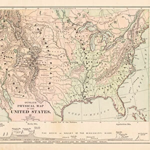
Metal Print : United States map 1881


![]()
Metal Prints from Fine Art Storehouse
United States map 1881
Harpers School Geography, New York, Harpers and Brothers, 1881
Unleash your creativity and transform your space into a visual masterpiece!
THEPALMER
Media ID 14756096
© This content is subject to copyright
Canada Commercial Industrial North America United States
14"x11" (28x35cm) Metal Print
Discover history with our stunning Metal Print of the United States Map from 1881 by THEPALMER from the Media Storehouse Fine Art Collection. This intricately detailed map, originally published by Harpers and Brothers in New York, transports you back in time with its vintage charm. The high-quality metal print not only showcases the map's historical significance but also adds a contemporary and elegant touch to any room. Bring a piece of the past into your modern space and start a conversation with this unique and captivating piece of art.
Our Metal Prints feature rounded corners and rear fixings for easy wall mounting. Images are directly printed onto a lightweight, high quality 5mm thick, durable metallic surface for a vivid and vibrant finish. Available in 2 sizes, 28x35cm (14x11) and 50x40cm (20x16). The unique material is fade, moisture, chemical and scratch resistant to help ensure this art lasts a lifetime.
Made with durable metal and luxurious printing techniques, metal prints bring images to life and add a modern touch to any space
Estimated Product Size is 35.5cm x 27.9cm (14" x 11")
These are individually made so all sizes are approximate
Artwork printed orientated as per the preview above, with landscape (horizontal) or portrait (vertical) orientation to match the source image.
FEATURES IN THESE COLLECTIONS
> Fine Art Storehouse
> Map
> Historical Maps
> Fine Art Storehouse
> Map
> USA Maps
EDITORS COMMENTS
This print showcases a vintage United States map from the year 1881, sourced from Harpers School Geography in New York. Published by Harpers and Brothers, this remarkable piece of history takes us back to an era when cartography was still in its infancy. The intricate details and artistic flair of this map are truly mesmerizing. The map encompasses not only the vast expanse of the United States but also includes Canada, providing a comprehensive view of North America during that time period. It offers a glimpse into the commercial and industrial landscape prevalent at the turn of the century, highlighting key trade routes and major cities that were instrumental in shaping these nations' economies. As we delve into this visual treasure trove, we are transported to an era where exploration and discovery were paramount. Each state is meticulously outlined with precision, showcasing their unique boundaries as they existed over a century ago. This historical artifact serves as a testament to our ever-evolving understanding of geography while reminding us how far we have come since then. Preserved through time by THEPALMER's expert craftsmanship, this print allows us to appreciate both the artistry behind antique maps and their invaluable role in documenting our past. Whether you're an avid collector or simply fascinated by history, this stunning piece will undoubtedly captivate your imagination while serving as a reminder of our rich cultural heritage.
MADE IN AUSTRALIA
Safe Shipping with 30 Day Money Back Guarantee
FREE PERSONALISATION*
We are proud to offer a range of customisation features including Personalised Captions, Color Filters and Picture Zoom Tools
SECURE PAYMENTS
We happily accept a wide range of payment options so you can pay for the things you need in the way that is most convenient for you
* Options may vary by product and licensing agreement. Zoomed Pictures can be adjusted in the Cart.