Metal Print > Granger Art on Demand > Maps
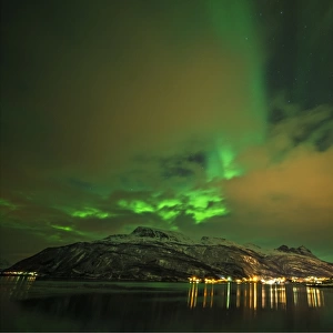
Metal Print : MAP: DANUBE. French map, 18th century, with instructions for navigating the Danube


![]()
Metal Prints from Granger
MAP: DANUBE. French map, 18th century, with instructions for navigating the Danube
MAP: DANUBE.
French map, 18th century, with instructions for navigating the Danube River upstream from Orsova, Romania
Granger holds millions of images spanning more than 25,000 years of world history, from before the Stone Age to the dawn of the Space Age
Media ID 12319791
Aerial View Danube Handwriting Instruction Navigation Romania Serbia Orsova
14"x11" (28x35cm) Metal Print
Discover the rich history of the Danube River with our stunning Metal Print of the 18th century French map, "MAP: DANUBE," from Granger Art on Demand. This exquisite piece features intricate details of the Danube's route upstream from Orsova, Romania, accompanied by valuable navigational instructions. Bring the old-world charm of cartography into your home or office with our high-quality Metal Print, which showcases vibrant colors and sharp details that are sure to impress. Each Metal Print is meticulously crafted using premium materials and state-of-the-art printing techniques, ensuring a long-lasting, museum-quality display. Elevate your decor and transport yourself to a bygone era with this captivating work of art.
Our Metal Prints feature rounded corners and rear fixings for easy wall mounting. Images are directly printed onto a lightweight, high quality 5mm thick, durable metallic surface for a vivid and vibrant finish. Available in 2 sizes, 28x35cm (14x11) and 50x40cm (20x16). The unique material is fade, moisture, chemical and scratch resistant to help ensure this art lasts a lifetime.
Made with durable metal and luxurious printing techniques, metal prints bring images to life and add a modern touch to any space
Estimated Product Size is 35.5cm x 27.9cm (14" x 11")
These are individually made so all sizes are approximate
Artwork printed orientated as per the preview above, with landscape (horizontal) or portrait (vertical) orientation to match the source image.
EDITORS COMMENTS
This print from Granger Art on Demand showcases a remarkable piece of history - a French map of the Danube River dating back to the 18th century. The intricate details and exquisite craftsmanship of this map are truly awe-inspiring. The aerial view depicted in this print offers a unique perspective, allowing us to appreciate the vastness and beauty of the Danube River as it winds its way through various countries. With handwritten instructions for navigating the river upstream from Orsova, Romania, this map served as an invaluable tool for sailors and explorers during that era. As we examine this historical artifact closely, we can't help but marvel at the meticulous attention given to every detail. The delicate handwriting adds an authentic touch, reminding us of a time when maps were carefully crafted by hand. This stunning piece not only serves as a visual delight but also provides insight into maritime navigation techniques used centuries ago. It is fascinating to imagine how sailors relied on such maps to navigate their way along the mighty Danube River. Whether you have an interest in cartography or simply appreciate art that tells stories of our past, this French map print is sure to captivate your imagination. Add it to your collection today and let it transport you back in time to an era filled with exploration and adventure along one of Europe's most iconic rivers – the Danube.
MADE IN AUSTRALIA
Safe Shipping with 30 Day Money Back Guarantee
FREE PERSONALISATION*
We are proud to offer a range of customisation features including Personalised Captions, Color Filters and Picture Zoom Tools
SECURE PAYMENTS
We happily accept a wide range of payment options so you can pay for the things you need in the way that is most convenient for you
* Options may vary by product and licensing agreement. Zoomed Pictures can be adjusted in the Cart.