Metal Print > Arts > Landscape paintings > Waterfall and river artworks > River artworks
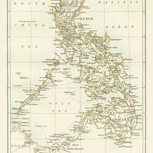
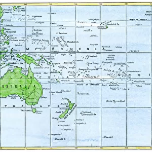
Metal Print : MAP: PHILIPPINES, 1905. Map of the Philippine Islands printed in the United States in 1905


![]()
Metal Prints from Granger
MAP: PHILIPPINES, 1905. Map of the Philippine Islands printed in the United States in 1905
Granger holds millions of images spanning more than 25,000 years of world history, from before the Stone Age to the dawn of the Space Age
Media ID 6617503
1905 Filipino Island Philippine Philippines
10"x8" (25x20cm) Table Top Metal Print
Discover history with our stunning Metal Prints featuring the vintage Map of the Philippine Islands from 1905. This intricately detailed map, originally printed by The Granger Collection in the United States, showcases the Philippine archipelago during a pivotal period in its history. Each Metal Print is meticulously crafted, transforming the map into a captivating work of art for your home or office. Embrace the rich history and beauty of this vintage map with our high-quality, long-lasting Metal Prints.
Table Top Metal Prints feature rounded corners and an easel back for easy display. Available in two sizes, 18x13cm (7x5) or 25x20cm (10x8). Lightweight and vibrant, they are perfect for displaying artwork and are guaranteed to add style to any desk or table top. The unique material is fade, moisture, chemical and scratch resistant to help ensure this art lasts a lifetime.
Made with durable metal and luxurious printing techniques, metal prints bring images to life and add a modern touch to any space
Estimated Product Size is 20.3cm x 25.4cm (8" x 10")
These are individually made so all sizes are approximate
Artwork printed orientated as per the preview above, with landscape (horizontal) or portrait (vertical) orientation to match the source image.
FEATURES IN THESE COLLECTIONS
> Granger Art on Demand
> Maps
> Arts
> Landscape paintings
> Waterfall and river artworks
> River artworks
> Asia
> Philippines
> Maps
> Asia
> Philippines
> Related Images
> Maps and Charts
> Early Maps
> Maps and Charts
> Related Images
EDITORS COMMENTS
This print showcases a historical artifact that takes us back to the early 20th century. The image features a meticulously detailed map of the Philippine Islands, printed in the United States in 1905. A testament to both cartographic precision and artistic craftsmanship, this map offers a glimpse into an era when exploration and discovery were at their peak. The intricate details on this vintage map allow us to explore the archipelago's diverse geography, from its lush islands to winding rivers that crisscross the landscape. It serves as a visual representation of the Philippines' rich history and cultural heritage, capturing not only its physical features but also its significance as an important hub for trade and commerce. Beyond its geographical importance, this map holds deeper meaning for Filipinos who take pride in their nation's past. It symbolizes resilience and independence during a time when colonial powers sought control over these beautiful islands. This piece is more than just ink on paper; it represents Filipino identity and serves as a reminder of our ancestors' struggles for freedom. Preserved by The Granger Collection, this remarkable photograph allows us to appreciate the artistry behind cartography while immersing ourselves in history. Whether you are an enthusiast of maps or simply intrigued by different cultures, this print is sure to transport you back in time and spark curiosity about one of Southeast Asia's most fascinating nations – the Philippines.
MADE IN AUSTRALIA
Safe Shipping with 30 Day Money Back Guarantee
FREE PERSONALISATION*
We are proud to offer a range of customisation features including Personalised Captions, Color Filters and Picture Zoom Tools
SECURE PAYMENTS
We happily accept a wide range of payment options so you can pay for the things you need in the way that is most convenient for you
* Options may vary by product and licensing agreement. Zoomed Pictures can be adjusted in the Cart.