Metal Print > Europe > United Kingdom > Scotland > Edinburgh > Edinburgh
Metal Print : Map of the German Empire, 1902. Creator: Unknown


![]()
Metal Prints from Heritage Images
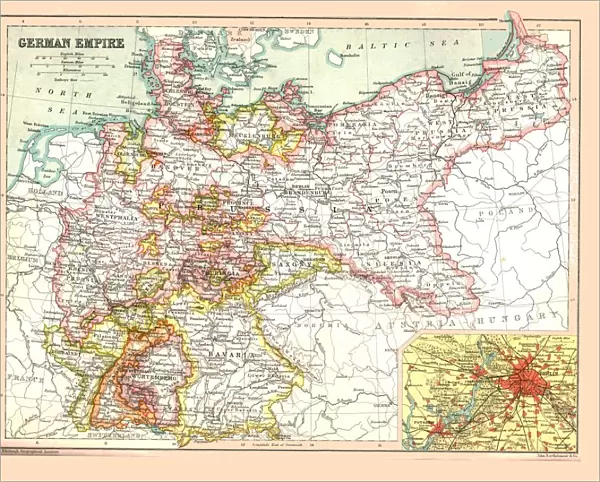
Map of the German Empire, 1902. Creator: Unknown
Map of the German Empire, 1902. Showing the German possessions of Alsace-Lorraine and Prussia, with inset of Berlin. From The Century Atlas of the World. [John Walker & Co, Ltd. London, 1902]
Heritage Images features heritage image collections
Media ID 15512350
© The Print Collector / Heritage-Images
Alsace Lorraine Edinburgh Geographical Institute German Empire Prussia
10"x8" (25x20cm) Table Top Metal Print
Step back in time with our exclusive Metal Print of the German Empire Map from 1902. This intricately detailed and historically significant piece, sourced from Heritage Images, showcases the German territories of Alsace-Lorraine and Prussia, along with an inset of Berlin. Our high-quality Metal Prints are known for their vibrant colors, sharp details, and long-lasting durability. Add this unique and captivating piece to your home or office decor, and bring a touch of history into your space.
Table Top Metal Prints feature rounded corners and an easel back for easy display. Available in two sizes, 18x13cm (7x5) or 25x20cm (10x8). Lightweight and vibrant, they are perfect for displaying artwork and are guaranteed to add style to any desk or table top. The unique material is fade, moisture, chemical and scratch resistant to help ensure this art lasts a lifetime.
Made with durable metal and luxurious printing techniques, metal prints bring images to life and add a modern touch to any space
Estimated Product Size is 25.4cm x 20.3cm (10" x 8")
These are individually made so all sizes are approximate
Artwork printed orientated as per the preview above, with landscape (horizontal) or portrait (vertical) orientation to match the source image.
FEATURES IN THESE COLLECTIONS
> Europe
> United Kingdom
> Scotland
> Edinburgh
> Edinburgh
> Europe
> United Kingdom
> Scotland
> Lothian
> Edinburgh
> Maps and Charts
> Related Images
> Maps and Charts
> World
EDITORS COMMENTS
This print showcases a Map of the German Empire from 1902, revealing the vast territorial holdings of Alsace-Lorraine and Prussia. The creator remains unknown, adding an air of mystery to this historical artifact. With its vibrant colors and intricate details, this map offers a glimpse into the geopolitical landscape of early 20th century Europe. The inclusion of an inset featuring Berlin highlights the significance of Germany's capital city during that time period. This particular print originates from The Century Atlas of the World, published by John Walker & Co in London in 1902. Its quality is further enhanced by being produced by the esteemed Edinburgh Geographical Institute. As we delve into this image, we are transported back in time to witness the might and power held within the German Empire at its peak. It serves as a reminder of Germany's influence on European politics and economics during this era. While we may never know who exactly created this remarkable piece, it continues to captivate viewers with its rich historical context and meticulous craftsmanship. As part of The Print Collector collection, it stands as a testament to our fascination with maps as both functional tools for navigation and beautiful works of art that tell stories about our world's past.
MADE IN AUSTRALIA
Safe Shipping with 30 Day Money Back Guarantee
FREE PERSONALISATION*
We are proud to offer a range of customisation features including Personalised Captions, Color Filters and Picture Zoom Tools
SECURE PAYMENTS
We happily accept a wide range of payment options so you can pay for the things you need in the way that is most convenient for you
* Options may vary by product and licensing agreement. Zoomed Pictures can be adjusted in the Cart.