Metal Print > Europe > Republic of Ireland > Cork
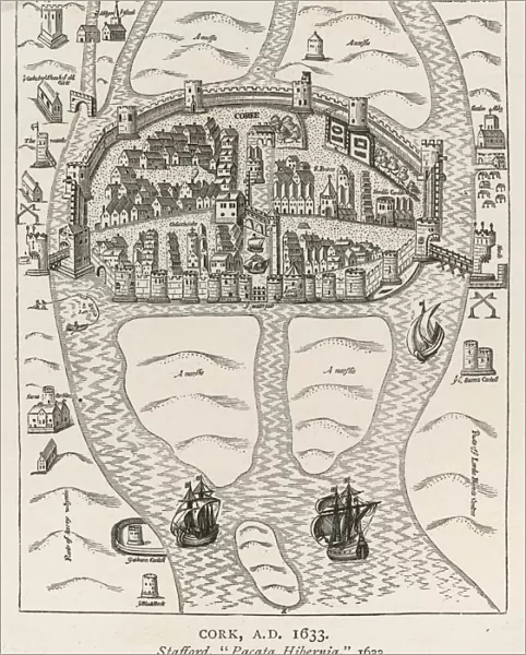
Metal Print : Ireland / Cork / 1633 Map


![]()
Metal Prints from Mary Evans Picture Library
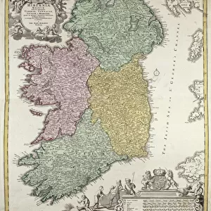
Ireland / Cork / 1633 Map
Primitive relief map of the city
Mary Evans Picture Library makes available wonderful images created for people to enjoy over the centuries
Media ID 4324917
© Mary Evans Picture Library 2015 - https://copyrighthub.org/s0/hub1/creation/maryevans/MaryEvansPictureID/10026009
10"x8" (25x20cm) Table Top Metal Print
Discover the rich history of Ireland with our stunning Media Storehouse Metal Prints featuring a primitive relief map of Cork from the year 1633. This captivating piece, sourced from Mary Evans Prints Online, showcases a rights managed image of Ireland's second largest city during an intriguing period in its history. The metal print's vibrant colors and textured surface bring the intricate details of this ancient map to life, making it a unique and eye-catching addition to any room. Transport yourself back in time and add a touch of history to your decor with our Ireland Cork 1633 Map Metal Print.
Table Top Metal Prints feature rounded corners and an easel back for easy display. Available in two sizes, 18x13cm (7x5) or 25x20cm (10x8). Lightweight and vibrant, they are perfect for displaying artwork and are guaranteed to add style to any desk or table top. The unique material is fade, moisture, chemical and scratch resistant to help ensure this art lasts a lifetime.
Made with durable metal and luxurious printing techniques, metal prints bring images to life and add a modern touch to any space
Estimated Product Size is 20.3cm x 25.4cm (8" x 10")
These are individually made so all sizes are approximate
Artwork printed orientated as per the preview above, with landscape (horizontal) or portrait (vertical) orientation to match the source image.
FEATURES IN THESE COLLECTIONS
> Europe
> Republic of Ireland
> Cork
> Europe
> Republic of Ireland
> Maps
> Maps and Charts
> Early Maps
> Maps and Charts
> Related Images
EDITORS COMMENTS
This stunning print captures a piece of history with an intricate map of Cork, Ireland from the year 1633. The primitive relief map showcases the city in incredible detail, highlighting its streets, buildings, and natural features. This historical artifact provides a fascinating glimpse into what Cork looked like over three centuries ago.
The texture of the relief map adds depth and dimension to the image, making it feel almost tangible as if you could reach out and touch the cityscape. The walls surrounding Cork are clearly delineated, giving insight into how the city was fortified during this time period.
As you study this map closely, you can imagine what life was like in Cork in 1633 - bustling markets, busy streets filled with merchants and traders, and ships coming in and out of the harbor. It's a snapshot frozen in time that allows us to connect with the past and appreciate how much has changed since then.
Whether you have a personal connection to Cork or simply appreciate history and cartography, this print is sure to captivate your imagination. Display it proudly on your wall as a conversation piece that will spark curiosity and admiration for centuries-old craftsmanship.
MADE IN AUSTRALIA
Safe Shipping with 30 Day Money Back Guarantee
FREE PERSONALISATION*
We are proud to offer a range of customisation features including Personalised Captions, Color Filters and Picture Zoom Tools
SECURE PAYMENTS
We happily accept a wide range of payment options so you can pay for the things you need in the way that is most convenient for you
* Options may vary by product and licensing agreement. Zoomed Pictures can be adjusted in the Cart.