Metal Print > Animals > Birds > Passerines > Finches > Atlantic Canary
Metal Print : Map of Tenerife, Canary Islands


![]()
Metal Prints from Mary Evans Picture Library
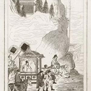
Map of Tenerife, Canary Islands
Map of Tenerife, Canary Islands, with soundings in fathoms. Date: 1838
Mary Evans Picture Library makes available wonderful images created for people to enjoy over the centuries
Media ID 14262791
© Mary Evans / Pharcide
1830s 1838 Atlantic Canaries Canary Chart Charts Maps Navigation Soundings Tenerife Fathoms
10"x8" (25x20cm) Table Top Metal Print
Discover the beauty and rich maritime history of Tenerife, the largest of the Canary Islands, with our stunning Metal Prints from Media Storehouse. This exquisite map, dated 1838, features detailed soundings in fathoms and is sourced from Mary Evans Prints Online. Each Metal Print is meticulously crafted with vibrant colors and a sleek, modern design, bringing the intricate details of this historic map to life. Perfect for adding a unique and captivating touch to any room in your home or office. Order now and bring a piece of the Canary Islands into your space.
Table Top Metal Prints feature rounded corners and an easel back for easy display. Available in two sizes, 18x13cm (7x5) or 25x20cm (10x8). Lightweight and vibrant, they are perfect for displaying artwork and are guaranteed to add style to any desk or table top. The unique material is fade, moisture, chemical and scratch resistant to help ensure this art lasts a lifetime.
Made with durable metal and luxurious printing techniques, metal prints bring images to life and add a modern touch to any space
Estimated Product Size is 25.4cm x 20.3cm (10" x 8")
These are individually made so all sizes are approximate
Artwork printed orientated as per the preview above, with landscape (horizontal) or portrait (vertical) orientation to match the source image.
FEATURES IN THESE COLLECTIONS
> Animals
> Birds
> Passerines
> Finches
> Atlantic Canary
> Animals
> Mammals
> Muridae
> Water Mouse
> Arts
> Artists
> O
> Oceanic Oceanic
> Europe
> France
> Canton
> Landes
> Maps and Charts
> Related Images
EDITORS COMMENTS
1. Title: "Exploring the Coastal Depths of Tenerife, Canary Islands: A 19th-Century Maritime Chart" This map print, dated 1838, offers a glimpse into the rich maritime history of Tenerife, the largest of the Canary Islands located in the Atlantic Ocean. The intricate detail of this chart reveals the island's coastline, its bays, and inlets, as well as the depth soundings measured in fathoms, providing essential information for safe navigation in the late 1800s. The map's vibrant colors and meticulous illustrations of the island's topography transport us back to the 1830s, an era of significant advancements in cartography and maritime exploration. The Atlantic Ocean surrounding Tenerife is depicted with a sense of realism, reflecting the importance of accurate charts for seafarers navigating the often treacherous waters of the region. The map's title, "Carte des Costes de Tenerife," is accompanied by the date "1838," and the scale of the chart is indicated in the bottom left corner. The soundings, measured in fathoms, are meticulously plotted along the coastline, providing valuable information for sailors seeking safe harbor or assessing the depth of the waters for anchoring their vessels. This map is a testament to the ingenuity and determination of cartographers and navigators of the past, who dedicated their lives to charting the world's oceans and making them safer for maritime travel. Today, it serves as a fascinating reminder of the rich maritime heritage of Tenerife and the Canary Islands.
MADE IN AUSTRALIA
Safe Shipping with 30 Day Money Back Guarantee
FREE PERSONALISATION*
We are proud to offer a range of customisation features including Personalised Captions, Color Filters and Picture Zoom Tools
FREE COLORIZATION SERVICE
You can choose advanced AI Colorization for this picture at no extra charge!
SECURE PAYMENTS
We happily accept a wide range of payment options so you can pay for the things you need in the way that is most convenient for you
* Options may vary by product and licensing agreement. Zoomed Pictures can be adjusted in the Cart.