Metal Print > Europe > Portugal > Maps
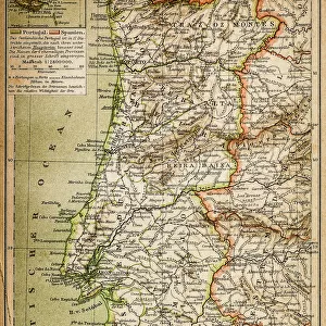
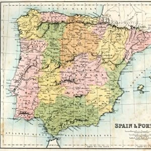
Metal Print : MAP / SPAIN / PORTUGAL 1827


![]()
Metal Prints from Mary Evans Picture Library
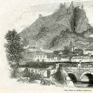
MAP / SPAIN / PORTUGAL 1827
Map of Spain and Portugal Date: 1827
Mary Evans Picture Library makes available wonderful images created for people to enjoy over the centuries
Media ID 20153873
© Bubblepunk
10"x8" (25x20cm) Table Top Metal Print
Discover the rich history of Europe with our stunning Metal Prints from Media Storehouse, featuring this intricately detailed map of Spain and Portugal from 1827, sourced from Mary Evans Prints Online. Each print is meticulously transferred onto a high-quality aluminum sheet, resulting in a vibrant, long-lasting image that adds an elegant touch to any room. The sleek, modern design of the metal print enhances the intricate lines and colors of the map, making it a captivating conversation starter. Bring history into your home with this beautiful and durable addition to your decor.
Table Top Metal Prints feature rounded corners and an easel back for easy display. Available in two sizes, 18x13cm (7x5) or 25x20cm (10x8). Lightweight and vibrant, they are perfect for displaying artwork and are guaranteed to add style to any desk or table top. The unique material is fade, moisture, chemical and scratch resistant to help ensure this art lasts a lifetime.
Made with durable metal and luxurious printing techniques, metal prints bring images to life and add a modern touch to any space
Estimated Product Size is 25.4cm x 20.3cm (10" x 8")
These are individually made so all sizes are approximate
Artwork printed orientated as per the preview above, with landscape (horizontal) or portrait (vertical) orientation to match the source image.
FEATURES IN THESE COLLECTIONS
> Mary Evans Prints Online
> New Images July 2020
> Europe
> Portugal
> Related Images
> Europe
> Related Images
> Europe
> Spain
> Related Images
> Maps and Charts
> Related Images
> Maps and Charts
> Spain
EDITORS COMMENTS
This map print, hailing from the year 1827, offers a detailed and intriguing glimpse into the geography of Europe during a pivotal historical period. The map focuses on the Iberian Peninsula, home to the nations of Spain and Portugal. At the time, both countries were undergoing significant political and territorial changes. The map's meticulous cartography reveals the borders of the two nations as they existed in 1827. Spain, with its vast territories in Europe and the Americas, is depicted in rich detail. Portugal, a maritime power with extensive colonies, is shown with its own distinct borders. The Strait of Gibraltar, the narrow waterway connecting the Atlantic Ocean to the Mediterranean Sea, is clearly marked, highlighting the strategic importance of this area for both nations. The map also includes various topographical features, such as mountains, rivers, and bays, providing valuable context for understanding the physical geography of the region. The inclusion of place names, both large and small, adds to the map's historical significance. Many cities, towns, and villages are labeled, offering a glimpse into the demographic and cultural makeup of the Iberian Peninsula during this time. This map is a testament to the art and science of cartography during the 19th century. Its intricate detail and historical accuracy make it an invaluable resource for scholars, historians, and anyone with an interest in the history of Europe and the world. The map serves as a reminder of the rich and complex history of Spain and Portugal, two nations that continue to shape the world in numerous ways.
MADE IN AUSTRALIA
Safe Shipping with 30 Day Money Back Guarantee
FREE PERSONALISATION*
We are proud to offer a range of customisation features including Personalised Captions, Color Filters and Picture Zoom Tools
SECURE PAYMENTS
We happily accept a wide range of payment options so you can pay for the things you need in the way that is most convenient for you
* Options may vary by product and licensing agreement. Zoomed Pictures can be adjusted in the Cart.