Metal Print > Europe > United Kingdom > England > Maps
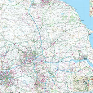
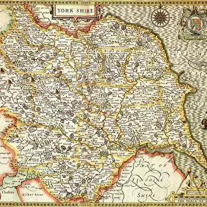
Metal Print : MAP / YORKSHIRE / NORTH 1857


![]()
Metal Prints from Mary Evans Picture Library
MAP / YORKSHIRE / NORTH 1857
Map of Yorkshire: North Riding, showing the east coast Date: circa 1857
Mary Evans Picture Library makes available wonderful images created for people to enjoy over the centuries
Media ID 20153859
© Bubblepunk
10"x8" (25x20cm) Table Top Metal Print
Discover the rich history of Yorkshire with our stunning Metal Prints from Media Storehouse, featuring this intricately detailed map of the North Riding from Mary Evans Prints Online. Dating back to circa 1857, this captivating map showcases the East Coast of Yorkshire in exquisite detail. The metal print process gives the image a vibrant, three-dimensional effect, making it a unique and eye-catching addition to any space. Bring a piece of historical Yorkshire into your home or office with this beautiful and durable metal print.
Table Top Metal Prints feature rounded corners and an easel back for easy display. Available in two sizes, 18x13cm (7x5) or 25x20cm (10x8). Lightweight and vibrant, they are perfect for displaying artwork and are guaranteed to add style to any desk or table top. The unique material is fade, moisture, chemical and scratch resistant to help ensure this art lasts a lifetime.
Made with durable metal and luxurious printing techniques, metal prints bring images to life and add a modern touch to any space
Estimated Product Size is 25.4cm x 20.3cm (10" x 8")
These are individually made so all sizes are approximate
Artwork printed orientated as per the preview above, with landscape (horizontal) or portrait (vertical) orientation to match the source image.
FEATURES IN THESE COLLECTIONS
> Mary Evans Prints Online
> New Images July 2020
> Europe
> United Kingdom
> England
> East Riding of Yorkshire
> Related Images
> Europe
> United Kingdom
> England
> Maps
> Europe
> United Kingdom
> England
> North Yorkshire
> Related Images
> Europe
> United Kingdom
> England
> Posters
> Europe
> United Kingdom
> England
> Related Images
> Europe
> United Kingdom
> England
> Yorkshire
> Related Images
> Maps and Charts
> Related Images
EDITORS COMMENTS
This intriguing antique map print, titled "Map of Yorkshire: North Riding, showing the east coast" from circa 1857, offers a captivating glimpse into the historical geography of northern England. The map, which is part of the vast collection at Mary Evans Prints Online, provides a detailed and accurate representation of the North Riding of Yorkshire during the Victorian era. The map's intricate cartography reveals the complex network of roads, rivers, and towns that dotted the landscape of North Yorkshire over 160 years ago. The east coastline, marked by the North Sea, is depicted with a high degree of precision, allowing viewers to trace the contours of the rugged cliffs and sandy beaches that once welcomed mariners and travelers from across the globe. The map's rich detail extends beyond its geographical features, however, as it also reveals the names of numerous towns, villages, and estates scattered throughout the region. These place names offer a fascinating window into the history and culture of North Yorkshire during the mid-19th century, providing a tangible connection to the people and communities that once called this area home. The map's antique charm is further enhanced by its elegant design, which features a decorative border and intricate cartouche. The use of hand-drawn lines and subtle color shading adds to the map's authenticity and historical appeal, making it an essential addition to any collection of antique maps or historical documents. Whether you are a historian, genealogist, or simply someone with a passion for the history of England, this Map of Yorkshire: North Riding, showing the east coast (circa 1857) is an invaluable resource that offers a unique and captivating glimpse into the past. With its rich detail and intricate design, this map is sure to inspire wonder and curiosity, transporting you back in time to a bygone era.
MADE IN AUSTRALIA
Safe Shipping with 30 Day Money Back Guarantee
FREE PERSONALISATION*
We are proud to offer a range of customisation features including Personalised Captions, Color Filters and Picture Zoom Tools
SECURE PAYMENTS
We happily accept a wide range of payment options so you can pay for the things you need in the way that is most convenient for you
* Options may vary by product and licensing agreement. Zoomed Pictures can be adjusted in the Cart.