Metal Print > Arts > Artists > R > Roman Roman
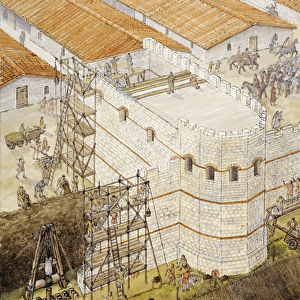
Metal Print : Outline of Old Roman Wall, shown on Map of London 1885


![]()
Metal Prints from Mary Evans Picture Library
Outline of Old Roman Wall, shown on Map of London 1885
Mary Evans Picture Library makes available wonderful images created for people to enjoy over the centuries
Media ID 19885774
© Mary Evans Picture Library
10"x8" (25x20cm) Table Top Metal Print
Step back in time with our captivating Media Storehouse Metal Prints, featuring an intriguing fusion of history and geography. This particular design showcases the Outline of Old Roman Wall as it appeared on an 1885 Map of London, sourced from the extensive archive of Mary Evans Prints Online. Each metal print is meticulously crafted, bringing the intricate details of the ancient Roman wall and the historical map to life. The high-quality metal print material not only enhances the image's vibrancy and depth but also provides a sleek, modern look that complements any decor. Delve into the rich history of London and make a bold statement with this unique and captivating piece.
Table Top Metal Prints feature rounded corners and an easel back for easy display. Available in two sizes, 18x13cm (7x5) or 25x20cm (10x8). Lightweight and vibrant, they are perfect for displaying artwork and are guaranteed to add style to any desk or table top. The unique material is fade, moisture, chemical and scratch resistant to help ensure this art lasts a lifetime.
Made with durable metal and luxurious printing techniques, metal prints bring images to life and add a modern touch to any space
Estimated Product Size is 25.4cm x 20.3cm (10" x 8")
These are individually made so all sizes are approximate
Artwork printed orientated as per the preview above, with landscape (horizontal) or portrait (vertical) orientation to match the source image.
FEATURES IN THESE COLLECTIONS
> Arts
> Artists
> R
> Roman Roman
> Europe
> United Kingdom
> England
> London
> Related Images
> Maps and Charts
> Related Images
EDITORS COMMENTS
This image, sourced from Mary Evans Prints Online, offers a glimpse into London's rich historical past. The photograph features an outline of the Old Roman Wall as it appeared in the late 19th century, as depicted on a map of London from 1885. The Old Roman Wall, a testament to the city's ancient heritage, once encircled the Roman settlement of Londinium, which was established around 43 AD. The wall, which is believed to have been constructed during the reign of Emperor Hadrian, served as a defensive barrier against invading forces. Measuring approximately 2.1 kilometers in length, the wall was made of limestone, flint, and mortar, and stood up to 6 meters high in some places. As London grew and prospered, the wall was gradually dismantled and its stones were reused for other building projects. By the 18th century, only a few scattered sections of the wall remained. However, in the 19th century, there was renewed interest in London's Roman past, and efforts were made to preserve and excavate the remaining sections of the wall. This map from 1885, which highlights the outline of the Old Roman Wall, reflects this renewed interest in the city's Roman heritage. The wall is shown in its fragmented state, with sections marked as "Roman Wall" and other sections shown as "Ruins." The map also includes other points of historical interest, such as the Tower of London and St. Paul's Cathedral. Today, visitors to London can still see remnants of the Old Roman Wall, which have been incorporated into modern buildings and public spaces. The wall serves as a reminder of the city's long and complex history, and continues to fascinate and inspire generations of Londoners and visitors alike.
MADE IN AUSTRALIA
Safe Shipping with 30 Day Money Back Guarantee
FREE PERSONALISATION*
We are proud to offer a range of customisation features including Personalised Captions, Color Filters and Picture Zoom Tools
SECURE PAYMENTS
We happily accept a wide range of payment options so you can pay for the things you need in the way that is most convenient for you
* Options may vary by product and licensing agreement. Zoomed Pictures can be adjusted in the Cart.