Metal Print : Three printed coloured maps


![]()
Metal Prints from Mary Evans Picture Library
Three printed coloured maps
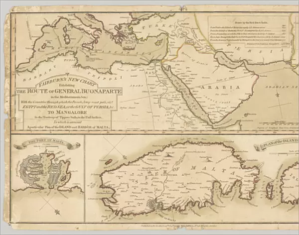
Three printed coloured maps: Fairburns New Chart Exhibiting the Route of General Buonaparte in the Mediterranean Sea; with the Countries through which the French Army must pass, viz Egypt and the Red Sea; or the Gulf of Persia, & to Mangalore in the Territory of Tippoo Sahib, in the East Indies. To which is annexed A Particular Plan of the Island and Harbour of Malna. Published 13 Aug 1798. Associated with the Wars of the French Revolution, Egypt (1799-1801). Date: 1798
Mary Evans Picture Library makes available wonderful images created for people to enjoy over the centuries
Media ID 14404024
© The National Army Museum / Mary Evans Picture Library
Chart Countries Exhibiting Gulf Maps Mediterranean Pass Persia Route Sahib Territory Three Tippoo Buonaparte Mangalore
14"x11" (28x35cm) Metal Print
Discover history in vibrant detail with Media Storehouse Metal Prints featuring three beautifully colored maps from Mary Evans Prints Online. These striking prints showcase "Fairburn's New Chart Exhibiting the Route of General Buonaparte in the Mediterranean Sea; with the Countries through which the French Army must pass." Each map is meticulously reproduced in high-definition and then transferred onto durable aluminum sheets for long-lasting, waterproof display. Add a touch of historical charm to your home or office with these captivating and conversation-starting decor pieces. Order yours today and bring the past to life in a whole new way.
Our Metal Prints feature rounded corners and rear fixings for easy wall mounting. Images are directly printed onto a lightweight, high quality 5mm thick, durable metallic surface for a vivid and vibrant finish. Available in 2 sizes, 28x35cm (14x11) and 50x40cm (20x16). The unique material is fade, moisture, chemical and scratch resistant to help ensure this art lasts a lifetime.
Made with durable metal and luxurious printing techniques, metal prints bring images to life and add a modern touch to any space
Estimated Product Size is 35.5cm x 27.9cm (14" x 11")
These are individually made so all sizes are approximate
Artwork printed orientated as per the preview above, with landscape (horizontal) or portrait (vertical) orientation to match the source image.
EDITORS COMMENTS
This trio of antique maps, published by Fairburns in 1798, offers a fascinating glimpse into the strategic plans of the French Army during the Wars of the French Revolution, specifically in the Mediterranean region and beyond. The most prominent map, titled "Fairburns New Chart Exhibiting the Route of General Buonaparte," illustrates the Mediterranean Sea and the countries through which the French Army, led by Napoleon Bonaparte, was expected to pass. These territories included Egypt and the Red Sea, as well as the Gulf of Persia and Mangalore in the domain of Tippoo Sahib in the East Indies. The second and third maps, attached as inserts, provide more detailed information about the Island and Harbour of Malna. The intricate depictions of these maps show the depth and breadth of the geographical knowledge available during this era, as well as the military strategies being considered during this pivotal time in history. The vibrant colors and meticulous detailing on these maps transport us back to the late 18th century, offering a captivating window into the world of exploration, conquest, and diplomacy. These maps not only serve as historical artifacts but also as beautiful works of art, showcasing the skill and craftsmanship of the mapmakers of the time. The "Fairburns New Chart Exhibiting the Route of General Buonaparte" and its accompanying maps offer a unique perspective on the military campaigns and global reach of the French Revolution, providing valuable insights into the geopolitical landscape of the time. These maps are a testament to the rich history of cartography and the enduring allure of exploration and discovery.
MADE IN AUSTRALIA
Safe Shipping with 30 Day Money Back Guarantee
FREE PERSONALISATION*
We are proud to offer a range of customisation features including Personalised Captions, Color Filters and Picture Zoom Tools
SECURE PAYMENTS
We happily accept a wide range of payment options so you can pay for the things you need in the way that is most convenient for you
* Options may vary by product and licensing agreement. Zoomed Pictures can be adjusted in the Cart.