Metal Print > Popular Themes > Railway Posters
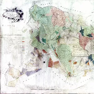
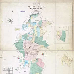
Metal Print : Map of Derbyshire with railways and proposed railways by J Archer, 1850


![]()
Metal Prints from Sheffield City Archives
Map of Derbyshire with railways and proposed railways by J Archer, 1850
Scale: 1.5 inches to 10 miles.
Size: approx 22 x 17 cm.
Original at Sheffield Libraries: y09199
Sheffield City Archives and Local Studies Library has an unrivalled collection of images of Sheffield, England
Media ID 14046836
© Sheffield City Council
Derbyshire Maps Norton Railways Beauchief
10"x8" (25x20cm) Table Top Metal Print
Discover the rich history of Derbyshire's railways with our stunning Metal Print of J Archer's 1850 Map from Sheffield City Archives. This intricately detailed map showcases the existing railways and proposed routes, offering a unique insight into the region's transportation history. Our high-quality Metal Print preserves the original's character with vibrant colors and sharp lines, making it a captivating addition to any home or office space. Experience the history of Derbyshire's railways like never before with our durable and water-resistant Metal Print.
Table Top Metal Prints feature rounded corners and an easel back for easy display. Available in two sizes, 18x13cm (7x5) or 25x20cm (10x8). Lightweight and vibrant, they are perfect for displaying artwork and are guaranteed to add style to any desk or table top. The unique material is fade, moisture, chemical and scratch resistant to help ensure this art lasts a lifetime.
Made with durable metal and luxurious printing techniques, metal prints bring images to life and add a modern touch to any space
Estimated Product Size is 20.3cm x 25.4cm (8" x 10")
These are individually made so all sizes are approximate
Artwork printed orientated as per the preview above, with landscape (horizontal) or portrait (vertical) orientation to match the source image.
FEATURES IN THESE COLLECTIONS
> Europe
> United Kingdom
> England
> Derbyshire
> Related Images
> Maps and Charts
> Related Images
> Popular Themes
> Railway Posters
> Sheffield City Archives
> Maps and Plans
> Maps of Derbyshire
EDITORS COMMENTS
This print showcases a historical gem, the "Map of Derbyshire with railways and proposed railways" meticulously crafted by J Archer in 1850. With its intricate details and exquisite design, this map takes us back to a time when rail travel was revolutionizing transportation in England. Spanning approximately 22 x 17 cm, this remarkable piece offers an intimate glimpse into the past. The scale of 1.5 inches to 10 miles ensures that every railway line and proposed route is accurately depicted, allowing viewers to trace the evolution of Derbyshire's transport network during this pivotal era. Nestled within Sheffield Libraries' esteemed collection at y09199, this artifact invites exploration into the rich history of Derbyshire's towns and villages. From Norton to Beauchief and Frecheville, each location on the map holds stories waiting to be discovered. As we admire this print from Sheffield City Archives, it is important to note that its significance extends beyond commercial use; it serves as a valuable educational resource for historians, researchers, or anyone captivated by the charm of old maps. This snapshot transports us back in time while reminding us how far we have come in terms of connectivity and progress. Let your imagination wander through these intricately drawn lines as you embark on a journey through Derbyshire's railway history - an adventure awaiting those who dare explore its secrets!
MADE IN AUSTRALIA
Safe Shipping with 30 Day Money Back Guarantee
FREE PERSONALISATION*
We are proud to offer a range of customisation features including Personalised Captions, Color Filters and Picture Zoom Tools
SECURE PAYMENTS
We happily accept a wide range of payment options so you can pay for the things you need in the way that is most convenient for you
* Options may vary by product and licensing agreement. Zoomed Pictures can be adjusted in the Cart.