Metal Print > Arts > Artists > B > Jacopo de' Barbari
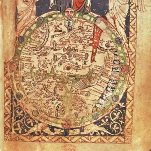
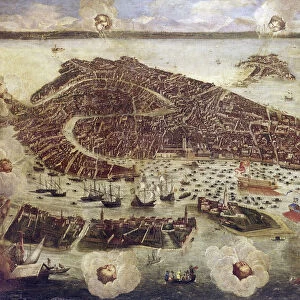
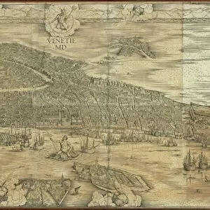
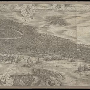
Metal Print : Map of Venice in 1500, by Jacopo de Barbari


![]()
Metal Prints from Universal Images Group (UIG)
Map of Venice in 1500, by Jacopo de Barbari
Cartography, Italy, 16th century. Map of Venice in 1500, by Jacopo de Barbari
Universal Images Group (UIG) manages distribution for many leading specialist agencies worldwide
Media ID 9505423
© DEA / A. DAGLI ORTI
16th Century City Map Cityscape Lagoon Panoramic Venice Jacopo De Barbari
14"x11" (28x35cm) Metal Print
Discover the rich history of Venice with our stunning Metal Print of the Map of Venice in 1500, by Jacopo de Barbari from Universal Images Group. This exquisite cartographic masterpiece, showcasing the intricate details of Venice in the 16th century, is now available as a high-quality Metal Print. The vibrant colors and sharp lines are beautifully preserved, making this a must-have for history enthusiasts, cartography collectors, and anyone who appreciates the beauty of old maps. Display this unique piece of art in your home or office and let the story of Venice come alive.
Our Metal Prints feature rounded corners and rear fixings for easy wall mounting. Images are directly printed onto a lightweight, high quality 5mm thick, durable metallic surface for a vivid and vibrant finish. Available in 2 sizes, 28x35cm (14x11) and 50x40cm (20x16). The unique material is fade, moisture, chemical and scratch resistant to help ensure this art lasts a lifetime.
Made with durable metal and luxurious printing techniques, metal prints bring images to life and add a modern touch to any space
Estimated Image Size (if not cropped) is 35.5cm x 17.5cm (14" x 6.9")
Estimated Product Size is 35.5cm x 27.9cm (14" x 11")
These are individually made so all sizes are approximate
Artwork printed orientated as per the preview above, with landscape (horizontal) orientation to match the source image.
FEATURES IN THESE COLLECTIONS
> Arts
> Artists
> B
> Jacopo Barbari
> Arts
> Artists
> B
> Jacopo de' Barbari
> Europe
> Italy
> Heritage Sites
> Venice and its Lagoon
> Europe
> Italy
> Veneto
> Venice
> Maps and Charts
> Italy
> Maps and Charts
> Related Images
> Universal Images Group (UIG)
> Art
> Painting, Sculpture & Prints
> Illustration And Painting
EDITORS COMMENTS
This stunning panoramic print showcases the intricate and detailed "Map of Venice in 1500" by renowned cartographer Jacopo de Barbari. A true masterpiece of Italian cartography from the 16th century, this antique map offers a captivating glimpse into the rich history and geography of Venice. With its horizontal layout, this illustration and painting beautifully captures the sprawling cityscape of Venice, depicting its labyrinthine canals, charming bridges, and magnificent architecture. The absence of people allows us to focus solely on the architectural marvels that make up this enchanting city. Jacopo de Barbari's meticulous attention to detail is evident as he skillfully portrays every nook and cranny of Venice's lagoon. From St. Mark's Square to Rialto Bridge, each landmark is meticulously rendered with precision and accuracy. As we explore this historical artifact, it transports us back in time to an era when gondolas glided through these very canals while merchants traded goods along bustling marketplaces. It serves as a testament to both Venetian ingenuity in urban planning and Jacopo de Barbari's artistic prowess. Whether you are a history enthusiast or simply captivated by beautiful illustrations, this print offers a unique window into one of Italy's most iconic cities during its golden age. Displayed proudly on any wall or study desk, it invites you to immerse yourself in centuries-old tales woven within the fabric of Venice itself.
MADE IN AUSTRALIA
Safe Shipping with 30 Day Money Back Guarantee
FREE PERSONALISATION*
We are proud to offer a range of customisation features including Personalised Captions, Color Filters and Picture Zoom Tools
SECURE PAYMENTS
We happily accept a wide range of payment options so you can pay for the things you need in the way that is most convenient for you
* Options may vary by product and licensing agreement. Zoomed Pictures can be adjusted in the Cart.