Metal Print > Maps and Charts > Africa
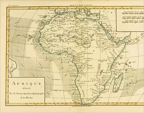
Metal Print : Map of Africa, circa. 1760. From Atlas de Toutes Les Parties Connues du Globe Terrestre


![]()
Metal Prints from Universal Images Group (UIG)
Map of Africa, circa. 1760. From Atlas de Toutes Les Parties Connues du Globe Terrestre
Map of Africa, circa.1760. From Atlas de Toutes Les Parties Connues du Globe Terrestre by Cartographer Rigobert Bonne. Published Geneva circa. 1760
Universal Images Group (UIG) manages distribution for many leading specialist agencies worldwide
Media ID 20165287
© Universal Images Group
Africa Color Colour Mapmaking Plate Welsh
14"x11" (28x35cm) Metal Print
Step back in time with our exquisite Metal Print of the Map of Africa, circa. 1760. This stunning vintage map, taken from the Atlas de Toutes Les Parties Connues du Globe Terrestre by Cartographer Rigobert Bonne, published in Geneva around 1760, showcases an intriguing and historically significant representation of the African continent. The intricate details of the map are beautifully preserved in our high-quality Metal Print, adding an elegant and sophisticated touch to any space. Transport yourself back to the 18th century with this captivating piece of cartographic history.
Our Metal Prints feature rounded corners and rear fixings for easy wall mounting. Images are directly printed onto a lightweight, high quality 5mm thick, durable metallic surface for a vivid and vibrant finish. Available in 2 sizes, 28x35cm (14x11) and 50x40cm (20x16). The unique material is fade, moisture, chemical and scratch resistant to help ensure this art lasts a lifetime.
Made with durable metal and luxurious printing techniques, metal prints bring images to life and add a modern touch to any space
Estimated Product Size is 35.5cm x 27.9cm (14" x 11")
These are individually made so all sizes are approximate
Artwork printed orientated as per the preview above, with landscape (horizontal) or portrait (vertical) orientation to match the source image.
FEATURES IN THESE COLLECTIONS
> Maps and Charts
> Related Images
> Universal Images Group (UIG)
> History
> Historical Maps
EDITORS COMMENTS
This stunning print showcases a rare and exquisite "Map of Africa" from the year 1760. Taken from the renowned Atlas de Toutes Les Parties Connues du Globe Terrestre by Cartographer Rigobert Bonne, this horizontal, color illustration offers a fascinating glimpse into the geography of Africa during that era. The intricate details and vibrant colors of this map bring to life the diverse landscapes and rich history of the African continent. From its northern deserts to its lush rainforests in the south, every corner is meticulously depicted with precision and artistry. Engraved on a plate by Welsh cartographer Ken, this masterpiece captures not only geographical features but also historical landmarks and cultural symbols unique to each region. It serves as a testament to the skillful craftsmanship involved in mapmaking during that time period. Published in Geneva around 1760, this Map of Africa holds immense historical value as it provides valuable insights into how our understanding of geography has evolved over centuries. It reminds us of the explorers who ventured into unknown territories, paving the way for future discoveries. With its timeless beauty and educational significance, this print is an ideal addition for any history enthusiast or lover of cartography. Whether displayed in homes or educational institutions, it invites viewers to embark on a visual journey through time while appreciating Africa's vastness and complexity.
MADE IN AUSTRALIA
Safe Shipping with 30 Day Money Back Guarantee
FREE PERSONALISATION*
We are proud to offer a range of customisation features including Personalised Captions, Color Filters and Picture Zoom Tools
SECURE PAYMENTS
We happily accept a wide range of payment options so you can pay for the things you need in the way that is most convenient for you
* Options may vary by product and licensing agreement. Zoomed Pictures can be adjusted in the Cart.